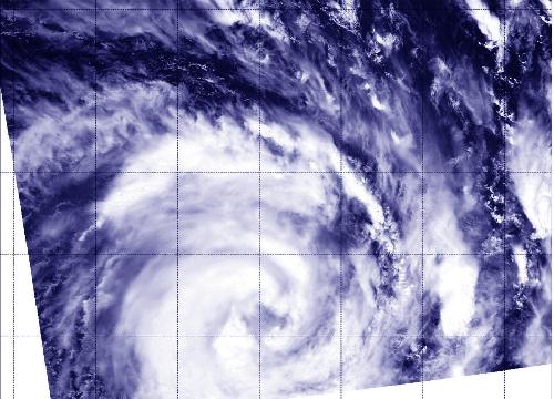
The Southern Indian Ocean's Tropical Cyclone Corentin achieved hurricane strength on Jan. 22 as NASA's Aqua satellite passed overhead.
When Aqua flew over Corentin on January 22, 2016 at 08:35 UTC (3:35 a.m. EST), the Moderate Resolution Spectroradiometer or MODIS instrument saw an eye forming. Bands of thunderstorms wrapped around the storm and into the center from the north and west.
At 1500 UTC (10 a.m. EST) on Jan. 22, Corentin's maximum sustained winds increased to 65 knots (75 mph/120 kph). It was centered near 20.2 degrees south latitude and 71.6 degrees east longitude, about 758 nautical miles (872 miles/1,404 km) south of Diego Garcia. Corentin was moving to the south-southwest at 14 knots (16.1 mph/25.9 kph). Corentin is no threat to any land areas.
 When Aqua flew over Corentin on Jan. 22, 2016, at 08:35 UTC (3:35 a.m. EST), the MODIS instrument saw an eye forming. Bands of thunderstorms wrapped around the storm and into the center from the north and west. Credit: Credits: NASA/NRL
The Joint Typhoon Warning Center noted that animated multispectral satellite imagery showed strong bands of thunderstorms wrapping tightly into a low-level circulation center. Microwave imagery showed an eye developing. Strongest convection (rising air that forms the thunderstorms that make up a tropical cyclone) were over the western and northern quadrants of the storm.
Warm waters in the vicinity are expected to help Corentin strengthen. The JTWC said that the system will begin moving on a southeast trajectory as the ridge (elongated area of high pressure) moves eastward.
source: NASA/Goddard Space Flight Center