Once a powerful Category 5 hurricane on the Saffir-Simpson Wind Scale, Tropical Cyclone Fantala continues to move north of Madagascar on April 21. NASA's Terra satellite and GPM satellite passed over the storm finding heavy rainfall, a clouded eye, and vertical wind shear affecting the storm as it turned in its track.
As expected, tropical cyclone Fantala reversed course and moved southeastward almost directly over its earlier track. The tropical cyclone's intensity also fluctuated. Maximum winds dropped significantly as Fantala moved southeastward but have rebounded somewhat on Wednesday, April 20.
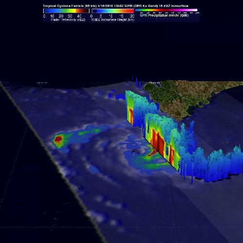
The Global Precipitation Measurement or GPM mission core observatory satellite flew over the tropical cyclone on April 19, 2016 at 1346Z (9:46 a.m. EDT) when winds had dropped to about 95 knots (109 mph). At that time GPM's Microwave Imager (GMI) and Dual-Frequency Precipitation Radar (DPR) found that Fantala still contained extremely heavy rainfall in storms spiraling into the tropical cyclone's northwestern side. GPM's radar (DPR) detected some heavy showers in that area that were dropping rain at a rate of over 209 mm (8.2 inches) per hour.
 On April 19, Fantala still contained extremely heavy rainfall in storms spiraling into the tropical cyclone's northwestern side. GPM's radar (DPR) detected some heavy showers in that area that were dropping rain at a rate of over 209 mm (8.2 inches) per hour. Credit: Credits: NASA/JAXA/SSAI, Hal Pierce
Data from GPM's radar (DPR Ku band) were used to show a 3-D cross section through the most intense rainfall within tropical cyclone Fantala. This view, looking toward the south, showed where strong showers in these bands were returning echoes greater than 53 dbz to the satellite indicating heavy rainfall. GPM is a joint missions between NASA and the Japanese space agency JAXA.
On April 21, the Moderate Resolution Imaging Spectroradiometer or MODIS instrument aboard NASA's Terra satellite captured a visible image of Tropical Cyclone Fantala as it was northeast of Madagascar. The MODIS image revealed that Fantala's eye had become obscured by clouds as the storm weakened. The storm also appeared somewhat elongated, likely because of northeasterly vertical wind shear
On April 21 at 0900 UTC (5 a.m. EDT), Tropical Cyclone Fantala's maximum sustained winds dropped to 90 knots (103.6 mph/ 166.7 kph). Fantala was still a Category 2 hurricane on the Saffir-Simpson Hurricane Wind Scale.
Fantala was centered near 12.3 degrees south latitude and 55.6 degrees east longitude, about 478 nautical miles north-northwest of Port Louis, Mauritius. Fantala continued to move to the east-southeast at 7 knots (8 mph/12.9 kph).
The Joint Typhoon Warning Center (JTWC) noted that animated enhanced infrared satellite imagery depicts deep convective (rising air that forms thunderstorms) banding wrapping into a defined center.
JTWC predicts that Fantala will turn back to the west-northwest after a day or two and head back north of Madagascar while maintaining status as a hurricane. The storm is expected to continue weakening as it moves towards Tanzania and northern Mozambique.
source: NASA/Goddard Space Flight Center