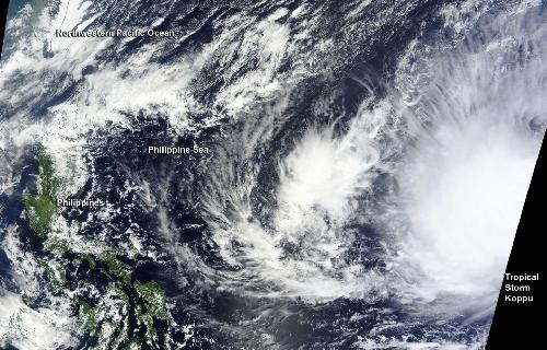
Tropical Storm Koppu formed in the Northwestern Pacific Ocean as a depression early on October 13 as NASA's Terra satellite passed over the storm and quickly intensified.
The Moderate Resolution Imaging Spectroradiometer or MODIS instrument that flies aboard NASA's Terra satellite captured an image of Tropical Storm Koppu as it was strengthening from a depression on October 13. Tropical Depression 24W formed at 0900 UTC (5 a.m. EDT) on October 13. By 1500 UTC (11 a.m. EDT), the depression strengthened into a tropical storm. The MODIS image showed a concentration of storms around the center of circulation.
At 11 a.m. EDT Tropical Storm Koppu's maximum sustained winds were near 40 knots (46 mph/74 kph). Koppu was centered near 15.8 North latitude and 138.1 East longitude, about 382 nautical miles north of Yap. Yap Island is located in the Caroline Islands and part of the Federated States of Micronesia.
 On Oct. 30, 2015 NASA's Terra satellite saw Tropical Storm Koppu in the Northwestern Pacific Ocean. Credit: Credits: NASA Goddard MODIS Rapid Response Team
Koppu was moving to the west at 11 knots (12.6 mph/20.3 kph). The Joint Typhoon Warning Center expects Koppu to move west toward the Philippines while intensifying steadily. Koppu is expected to peak at 120 knots (138.1 mph/222.2 kph) on October 17, on approach to Luzon, Philippines.
source: NASA/Goddard Space Flight Center