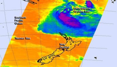
NASA's Aqua satellite caught an infrared picture of Tropical Cyclone Lusi after it transitioned into an extra-tropical storm, north of New Zealand. Gale Warnings are in effect in Northern New Zealand.
NASA's Aqua satellite passed over Lusi on March 13 at 13:41 UTC/9:41 a.m. EDT and the Atmospheric Infrared Sounder instrument captured infrared data on the storm that revealed it had become a cold-core system. When a storm becomes extra-tropical and its core changes from warm to cold, the strongest winds spread out and the storm expands.
The Joint Typhoon Warning Center issued their final bulletin on Lusi on March 13 at 2100 UTC/5 p.m. EDT. At that time, Lusi's maximum sustained winds were still near 50 knots/57.5 mph/92.6 kph. Lusi was centered near 26.7 south and 173.2 east, about 476 nautical miles/547.8 miles/881.6 km southwest of Suva, Fiji and the extra-tropical storm was moving to the south-southwest at 15 knots/17.2 mph/27.7 kph.

NASA's Aqua satellite passed over Lusi on March 13 at 13:41 UTC and infrared data revealed it had become a cold-core system.
(Photo Credit: NASA JPL, Ed Olsen)
On March 14, the New Zealand Meteorological Service noted that Lusi had picked up speed to 35 kph. Lusi's current track is expected to bring the storm just to the northwest of North Cape around midday Saturday, March 15.
The Brett coastal forecast issued at 4:25 a.m. on Saturday, March 15 (local time) includes a Gale Warning as the Met service expects "southeast winds of 45 knots/51.7 mph/83.3 kph turning northeast late morning and easing to 35 knots/40.2 mph/64.8 kph this evening. High sea easing. Northeast swell rising to 4 meters/13.1 feet. Poor visibility in heavy rain. "
The Met Service expects Lusi to move southward over the ocean west of the North Island on March 15 and early on March 16 (local time) then cross the South Island to just east of Canterbury Sunday night . For updates on the extra-tropical storm, visit: http://www.metservice.com/national/home
Source: NASA/Goddard Space Flight Center