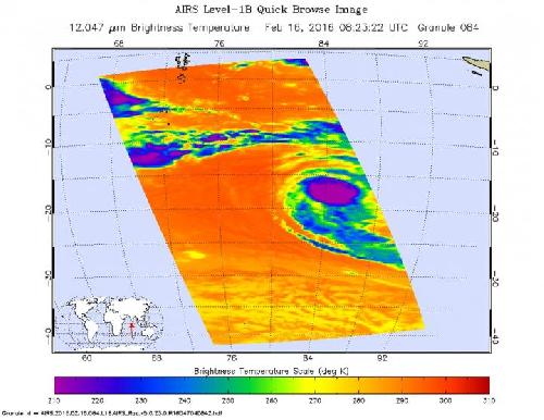
Cloud top temperatures in storms within Tropical Cyclone Uriah grew colder over the last couple of days, according to infrared imagery from NASA's Aqua satellite. That's an indication of stronger uplift in a tropical cyclone and a stronger storm. NASA-NOAA's Suomi NPP satellite saw the storm when it was struggling against wind shear, and two days later NASA's Aqua satellite saw Uriah reach hurricane-strength after the shear weakened.
On Feb 14 at 07:55 UTC (2:55 a.m. EST) NASA-NOAA's Suomi NPP satellite passed over Tropical Cyclone Uriah and the Visible Infrared Imaging Radiometer Suite (VIIRS) instrument aboard saw a strengthening storm with a developing eye. The VIIRS visible image showed bands of thunderstorms wrapping into the center. At that time, Uriah was still dealing with moderate to strong vertical wind shear finally abated and allowed the storm to reach hurricane-strength two days later.
On Feb. 16 the Atmospheric Infrared Sounder (AIRS) instrument aboard Aqua saw cloud top temperatures exceeding -63 degrees Fahrenheit (-53 degrees Celsius) tightly around the center of circulation. Storms with cloud tops that cold are very high into the troposphere and have the capability of producing heavy rainfall. The eye was 16 nautical miles wide.
 On Feb. 16 the AIRS instrument aboard NASA's Aqua satellite saw cloud top temperatures exceeding -63F/-53C in powerful storms tightly around Uriah's center of circulation. Credit: Credits: NASA JPL, Ed Olsen
At 1500 UTC (10 a.m. EST) Tropical Cyclone Uriah was at hurricane-force with maximum sustained winds near 75 knots (86.3 mph/138.9 kph). It was located near 18.0 degrees south latitude and 84.2 degrees east longitude. That's about 946 nautical miles (1,089 miles/1,752 km) southeast of Diego Garcia. Uriah was moving to the west at 11 knots (12.6 mph/20.3 kph).
The Joint Typhoon Warning Center expects Uriah to continue to move west into the central Indian Ocean. The storm is expected to intensify to 95 knots (109.3 mph/175.9 kph) after a day or so before curving to the southwest and weakening. Uriah poses no threat to land areas.
source: NASA/Goddard Space Flight Center