The former tropical storm known as 30W that moved from the western North Pacific Ocean basin into the northern Indian Ocean appears to be ramping up for a short stint at depression status again. NASA's TRMM satellite noticed some areas of heavy rainfall in the re-generating low pressure area.
Ex-tropical storm 30W is currently a low pressure area located near 12.0 north and 84.5 east, approximately 250 nautical miles east-southeast of Chennai, India. 30W had maximum sustained winds as high as 30 knots/34.5 mph/55.5 kph, so it's on the edge of tropical depression status. The low is moving to the west-southwest at 9 knots/10.3 mph/16.6 kph and expected to continue in that direction until it makes landfall.
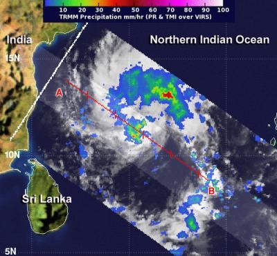
NASA's Tropical Rainfall Measuring Mission or TRMM satellite captured imagery that showed areas of heavy rain, rain falling at a rate of over 50 mm/2 inches per hour, were occurring northeast of the center of circulation. Thunderstorms in that quadrant were as high as 10 km/6.2 miles high. Satellite data also showed the bands of thunderstorms had developed around the center of circulation.

NASA's TRMM satellite saw heavy rain, rain falling at a rate of over 50 mm/2 inches per hour northeast 30W's center (red). Thunderstorms in that quadrant were as high as 10 km/6.2 miles high.
(Photo Credit: Image : SSAI/NASA, Hal Pierce)
Warnings have already been posted along the coast of southeastern India as the re-developing low with heavy rain is expected to make landfall in the next day or two. By Friday, Nov. 15, heavy rainfall of up to 10 inches is expected over northern Tamil Nadu and southern Andhra Pradesh.
The low pressure area is expected to continue tracking to the west-southwest and approach southeastern India and northern Sri Lanka in the next two days and has a high chance of making landfall at least as a tropical depression.
Source: NASA/Goddard Space Flight Center