There are two developing areas of tropical low pressure that lie east and west of Queensland, Australia. System 96P and System 98P, respectively. The MODIS instrument that flies aboard both NASA's Aqua and Terra satellites captured images of both tropical trouble-makers as each satellite passed overhead on March 7.
In the Coral Sea, part of the Southwestern Pacific Ocean, System 96P was just 125 nautical miles/143.8 miles/231.5 km north-northeast of Willis Island, Australia. It was centered near 14.3 south latitude and 150.6 east longitude. System 96P is moving in south-southwesterly direction toward Willis Island and the Queensland mainland. As a result, a Cyclone Watch is in effect for coastal areas from Cairns to Mackay.
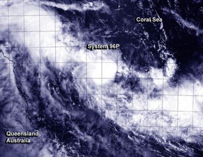
NASA's Aqua satellite passed over developing System 96P in the Coral Sea on March 7 at 03:25 UTC when the Moderate Resolution Imaging Spectroradiometer or MODIS instrument captured a visible image of the storm. MODIS image showed the strongest thunderstorms were west and south of the center of circulation.

NASA's Aqua satellite passed over developing System 96P in the Coral Sea on Mar. 7 at 03:25 UTC when the MODIS instrument captured this image.
(Photo Credit: US Naval Research Laboratory/NASA)
The Joint Typhoon Warning Center noted that animated multispectral satellite imagery revealed that the low-level circulation center is broad, and like the MODIS imagery, showed there are bands of thunderstorms wrapping into it, mostly from the southern and western quadrants. An image from the Advanced Scatterometer instrument called ASCAT provides evidence that the low is strengthening. ASCAT can measure surface winds and indicated that the low has 25 to 30 knot/28.7 to 34.5 mph/46.3 to 55.5 kph winds wrapping into the northern semi-circle.
Willis Island reported sustained winds that match ASCAT readings, southeasterly winds sustained between 25 to 30 knots.
The Australian Bureau of Meteorology expects System 96P to strengthen and approach the eastern Queensland coast near Bowen by 10 p.m. local time on March 9.
Second System Poised to Affect Queensland
To the west of Queensland in the northern Gulf of Carpentaria lies System 98P. That tropical low pressure area was centered near 9.8 south latitude and 138.4 east longitude about 175 nautical miles/201.4 miles/324.1 km north-northeast of Gove Airport, Australia.
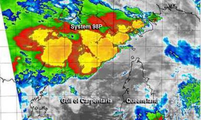
Another MODIS instrument that flies aboard NASA's Terra satellite provided an infrared image of developing System 98P on March 7 at 15:55 UTC. The MODIS image showed that 98P had some strong convection and strong thunderstorms developing west of the center.
As System 98P continues to approach Queensland, a Cyclone Watch was declared for coastal areas from Kowanyama to Cape Grenville, including the Torres Trait Islands. The Australian Bureau of Meteorology expects this low to intensify before making landfall near Weipa at 10 p.m. local time on March 9.
The Joint Typhoon Warning Center or JTWC identified an area of persistent deep convection over the western semi-circle and curved bands of thunderstorms in the western quadrant of the storm. ASCAT imagery showed that the storm has an elongated circulation with primarily 20 to 25 knot/23.0 to 28.7 mph /37.0 to 46.3 kph winds. JTWC gives System 98P a medium chance for development in the next day.

This infrared image of developing System 98P was taken on Mar. 7 at 15:55 UTC from the MODIS instrument aboard NASA's Terra Satellite. 98P showed some strong convection (yellow areas).
(Photo Credit: US Naval Research Laboratory/NASA)
Source: NASA/Goddard Space Flight Center