NASA's TRMM and Aqua satellites showed how Tropical Cyclone Narelle has fallen far from being a powerful cyclone in the Southern Indian Ocean. A time series of infrared images from an Aqua satellite instrument provides a clear picture of Narelle's former power and its recent demise, while TRMM 3-D data showed falling cloud heights and weaker rainfall.
Narelle, once a powerful tropical cyclone with winds of 115 knots (~132 mph), was equivalent to a category 4 hurricane on the Saffir-Simpson scale. The storm has continued to steadily weaken as it made its way southward paralleling the coast of Western Australia.
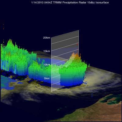
The Tropical Rainfall Measuring Mission or TRMM satellite is a joint mission between NASA and the Japanese Space Agency. TRMM captured an image of Narelle at 04:04 UTC (12:04 pm Australian Western Standard Time) on January 14, 2013. At the time, the center of circulation was located about 350 km (~215 miles) due west of the coast of Australia, and the storm's intensity was down to a category 2 cyclone--equivalent to a category 1 hurricane. TRMM revealed that the intense rainbands previously surrounding the storm had greatly diminished in size and intensity and no longer wrapped completely around the storm.
TRMM saw mostly moderate rainfall located southeast of the center, and revealed that an eye was no longer visible. TRMM Precipitation Radar instrument data was used to create a 3-D image of the storm that showed most of the highest cloud tops had diminished, although some moderately high tops (around 10 km) remain in an area of moderate rain, located southeast of the center.

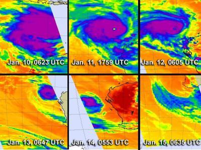
This series of infrared images of Cyclone Narelle was taken over 6 days by the AIRS instrument that flies aboard NASA's Aqua satellite. It shows the growth into a cyclone and weakening back to a tropical storm. The purple areas are the coldest cloud top temperatures, and strongest storms with heaviest rainfall occurring in the cyclone. Top row L to R: Jan. 10 at 0623 UTC; Jan. 11 at 1759 UTC; Jan. 12 at 0605 UTC. Bottom row, L to R: Jan. 13 at 0647 UTC; Jan. 14 at 0553 UTC; and Jan. 15 at 0635 UTC.
(Photo Credit: : NASA JPL, Ed Olsen)
Infrared date from NASA's Aqua satellite provided a look at the life of Narelle, from its peak to its end. A time series of infrared images of Cyclone Narelle was taken over 6 days by the Atmospheric Infrared Sounder (AIRS) instrument that flies aboard NASA's Aqua satellite. AIRS data showed Cyclone Narelle's growth into a cyclone, where the storm developed a clear eye on infrared imagery. At the time of peak intensity, AIRS infrared data indicated that that thunderstorms around the eye were so strong and so high in the atmosphere, that infrared data indicated they had temperatures of -63F (-52C). By Jan. 15, AIRS data showed that Narelle had been blown apart by wind shear. AIRS data was captured on Jan. 10 at 0623 UTC; Jan. 11 at 1759 UTC; Jan. 12 at 0605 UTC; Jan. 13 at 0647 UTC; Jan. 14 at 0553 UTC; and Jan. 15 at 0635 UTC.
The Joint Typhoon Warning Center issued their final warning on Narelle on Jan. 14 at 2100 UTC (8 p.m. EST/U.S.). At that time Narelle's maximum sustained winds were near 35 knots (40 mph/64.8 kph), and it had become extra-tropical. The center was located near 29.9 south latitude and 110.2 east longitude. It was moving to the south at 18 knots (20.7 mph/33.3 kph).
On Jan. 15, wind shear had taken its toll on Narelle, and had blown the storm apart. AIRS infrared imagery from NASA's Aqua satellite on Jan. 15 showed that Narelle's remnants appeared more like a paint brush stroke from north to southeast, with no discernable center. Narelle's remnants were south of Perth, near Cape Leeuwin where they are expected to dissipate.
As Narelle continues to dissipate, the Australian Bureau of Meteorology maintained a strong wind warning for the following areas: Perth Local Waters, Lancelin Coast, Perth Coast and Bunbury Geographe Coast.
Narelle was the second cyclone to the form in the southern Indian Ocean this year. Cyclone Dumile passed east of Madagascar the first week of the year--and the fourth of the season. Typically there are about 9 tropical storms per season in the southern Indian Ocean, which runs year round from July through June.

On Jan. 14, NASA's TRMM satellite saw mostly moderate rain (in green) southeast of Tropical Storm Narelle's center. An eye is no longer visible. The 3-D image shows some moderately high tops (around 10 km, shown in orange) remain in the area of moderate rain southeast of the center.
(Photo Credit: : SSAI/NASA, Hal Pierce)
Source: NASA/Goddard Space Flight Center