Tropical Cyclone 03A made landfall in Somalia and moved inland where it is dissipating over eastern Ethiopia today, Nov. 12. NASA's Aqua, Terra and TRMM satellites passed over the cyclone an captured images of 03A before and after it made landfall.
Somalia is located in the Horn of Africa and its coastline lies on the Arabian Sea and the Gulf of Aden. It is bordered by Ethiopia to the west, and Djibouti to the northwest.
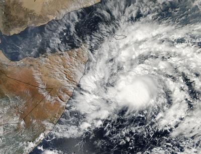
On Nov. 8, NASA's Aqua satellite passed over Tropical Cyclone 03A and the Moderate Resolution Imaging Spectroradiometer or MODIS instrument captured a visible image of the storm at 10:05 UTC/5:05 a.m. EDT. The MODIS image showed a concentrated area of thunderstorms around the center of circulation.

On Nov. 8 at 10:05 UTC/5:05 a.m. EDT NASA's Aqua satellite captured this visible image of Tropical Cyclone 3A in the Arabian Sea approaching Somalia.
(Photo Credit: Image : NASA Goddard MODIS Rapid Response Team)
On Nov. 10 at 1500 UTC/10 a.m. EDT, Tropical Cyclone 03A was centered near 8.3 north latitude and 51.2 east longitude about 175 nautical miles south-of Ras Binnah, Somalia. It was moving to the northwest at 4 knots/4.6 mph/7.4 kph and had maximum sustained winds near 35 knots/40 mph/64.8 kph, making it a minimal tropical storm. The strongest convection was pushed west of the center by easterly wind shear. Precipitation radar imagery from NASA's Tropical Rainfall Measuring Mission or TRMM satellite showed the strongest thunderstorms were dropping rainfall at a rate of 1 inch per hour northwest of the center.
On Nov. 11, Tropical Cyclone 03A made landfall in east central Somalia with sustained winds of tropical-storm force. Maximum sustained winds were near 35 knots/40 mph/64.8 kph at the time of landfall. On Nov. 11 at 0300 UTC/Nov. 10 at 10 p.m. EDT, TC03A was centered near 8.5 north and 49.7 east, about 175 nautical miles south-southwest of Ras Binnah, Somalia. It was moving west at 8 knots/9.2 mph/14.8 kph.

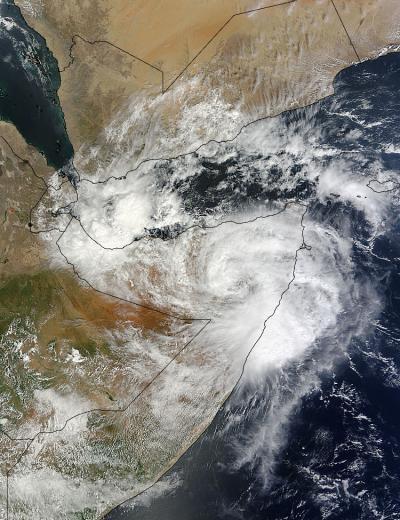
On Nov. 11 at 07:35 UTC/2:35 a.m. EDT NASA's Terra satellite captured this image of Tropical Cyclone 03A over Somalia.
(Photo Credit: Image : NASA Goddard MODIS Rapid Response Team)
On Nov. 11 at 07:35 UTC/2:35 a.m. EDT the MODIS instrument that flies aboard NASA's Terra satellite captured an image of Tropical Cyclone 03A post-landfall and moving over Somalia.
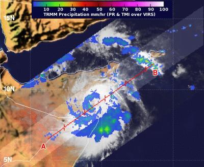
NASA's Tropical Rainfall Measuring Mission satellite called TRMM captured data on rainfall rates within the storm after it made landfall at 0345 UTC on Nov.11. TRMM showed light rainfall throughout most of the tropical storm with areas of moderate rain in the northwestern and east to southeastern quadrants. In the areas of moderate rain, rain was falling at up to 1.18 inches/30 mm per hour. Infrared imagery showed that TC03A maintained its symmetry after it made landfall.
The tropical storm is expected to dissipate over land later today, Nov. 12.

On Nov. 11 at 0345 UTC, NASA's TRMM satellite showed light rainfall throughout most of 03A with moderate (green) rain (at up to 1.18 inches/30 mm per hour) in the northwestern and east to southeastern quadrants.
(Photo Credit: Image : SSAI/Hal Pierce)
Source: NASA/Goddard Space Flight Center