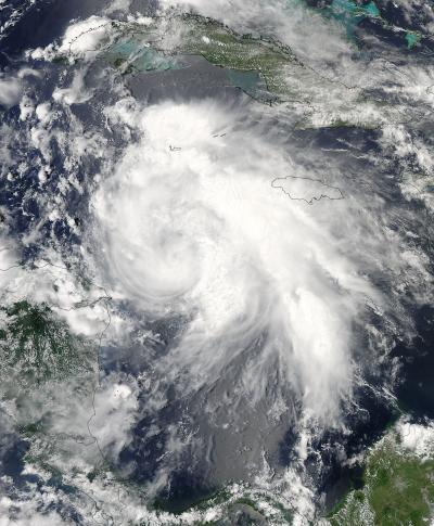
The National Hurricane Center warned that Ernesto is expected to produce rainfall accumulations of 3 to 5 inches along the northern coast of honduras...with isolated amounts as high as 8 inches over mountainous terrain. Belize, the Yucatan Peninsula and northern Guatemala can expect between 4 and 8 inches with as much as a foot of rain in isolated areas, so flooding is expected and mudslides are possible.
A Tropical Storm Watch is in effect for the coast of Honduras from west of Punta Sal to the Honduras/Guatemala border.
At 8 a.m. EDT, Tropical Storm Ernesto's maximum sustained winds were near 65 mph (100 kmh) with higher gusts. The National Hurricane Center (NHC) expects Ernesto to strengthen into a hurricane before it makes landfall. The center of Tropical Storm Ernesto was located near latitude 17.8 north and longitude 84.4 west, about 250 miles (405 km) east of Belize City, Belize and about 180 miles (285 km) northeast of the island of Roatan, Honduras, where cruise ships are known to stop.
According to USA Today on-line, the Carnival Legend cruise ship is skipping stops near Belize and Honduras because of the tropical storm.
Ernesto is moving toward the west-northwest near 13 mph (20 kmh). The NHC expects Ernesto to keep moving to the west-northwest tonight and turn west on Wednesday, August 8, moving across the Yucatan Peninsula tonight and early Wednesday where it will emerge over the Bay of Campeche.
Watching Other Atlantic Lows
Meanwhile in the Atlantic Ocean, there are two other areas of low pressure that bear watching. One is a tropical wave located several hundred miles southwest of the Cape Verde Islands in the eastern Atlantic Ocean. The center is elongated, and the low is generating showers and thunderstorms. The NHC gives it a 20 percent chance for becoming a tropical depression in the next two days.
The second area was once Tropical Storm Florence and is now a remnant low pressure area. Showers have increased, but the atmospheric conditions are not conducive to strengthening. The remnants of post-tropical storm Florence are located about 1,000 miles east of the Northern Leeward Islands and the NHC gives it just a 10 percent chance of reforming.

This visible image of Tropical Storm Ernesto was captured from NOAA's GOES-13 satellite on Aug. 7, 2012, at 1425 UTC (10:25 a.m. EDT) as it was approaching Belize and Mexico's Yucatan Peninsula. Although Ernesto does not yet have a visible eye on satellite imagery, it is expected to strengthen into a hurricane before landfall. *By 2 p.m. EDT, it strengthened into Hurricane Ernesto.*
(Photo Credit: : NASA GOES Project)

This visible image of Tropical Storm Ernesto approaching Central America was captured by the MODIS instrument onboard NASA's Aqua satellite on Aug. 6, 2012 at 1840 UTC (2:40 pm EDT). The strongest storms appear to be on the northern and eastern sides of the storm.
(Photo Credit: : NASA Goddard MODIS Rapid Response Team)
Source: NASA/Goddard Space Flight Center