Two NASA Satellites confirmed that the heaviest rainfall in Tropical Storm Bret is occurring in the eastern side of the storm. One satellite using precipitation radar measured rainfall, and another satellite using infrared light measured cloud-top temperatures which indicate strength of thunderstorms.
The Tropical Rainfall Measuring Mission (TRMM) satellite flew over tropical storm Bret in the Atlantic Ocean north of the Bahamas on July 19, 2011 at 1118 UTC ( 7:18 a.m. EDT). The early morning pass showed that Bret was very small but TRMM's Precipitation Radar showed that the storm had some powerful thunderstorms reaching to heights of 15km (9.3 miles) in the eastern quadrant of the storm.
NASA's Aqua satellite passed over Tropical Storm Bret seven hours later than TRMM did on July 19 at 18:35 UTC (2:35 p.m. EDT). NASA's Atmospheric Infrared Sounder (AIRS) imagery confirmed what TRMM showed by measuring very cold (-63F/-52C) cloud top temperatures. Bret still had strong thunderstorms east of the center of circulation.
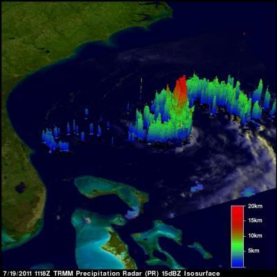
NASA's TRMM satellite captured this image of rainfall happening within Tropical Stort on July 19. The strongest thunderstorms were as high as 9.3 miles (15 km) and had the heaviest rainfall (red) on the east side of the storm, falling at 2 inches (50 mm) per hour. The yellow and green areas indicate moderate rainfall between .78 to 1.57 inches (20 to 40 mm) per hour.
(Photo Credit: NASA/SSAI, Hal Pierce)
At 5 a.m. EDT Tropical Storm Bret's maximum sustained winds were near 50 mph (85 kmh) although gradual weakening is forecast to occur over the next two days. Bret's center is near latitude 31.1 North and longitude 74.4 West. Bret is moving toward the northeast near 7 mph (11 kmh) and is expected to continue in that direction while speeding up. Bret's minimum central pressure is 1001 millibars.
Bret is forecast to run into strong wind shear and dry air, two factors that will take the wind out of his sails in the next couple of days.
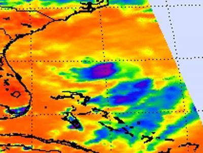
NASA's Aqua satellite passed over Tropical Storm Bret on July 19 at 18:35 UTC (2:35 p.m. EDT). NASA's AIRS infrared imagery showed strong thunderstorms east of the center of circulation (purple).
(Photo Credit: NASA/JPL, Ed Olsen)
Source: NASA/Goddard Space Flight Center