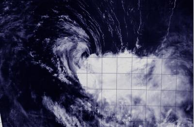
A visible image from NASA's Aqua satellite provides a clear picture that wind shear is responsible for weakening the once mighty Tropical Cyclone Gillian from hurricane to tropical storm strength.
When NASA's Aqua satellite flew over Gillian on March 25 at 06:30 UTC/2:30 a.m. EDT, the Moderate Resolution Imaging Spectroradiometer or MODIS instrument took a visible picture of the storm. That image showed that wind shear has pushed clouds and showers away from the center as the storm weakened to a tropical storm.
In the MODIS image, the center of Gillian's circulation is surrounded by some cloudiness, while the bulk of clouds and showers has been pushed to the east-southeast from wind shear from the northwest.

NASA's Aqua satellite captured this image of Gillian on March 25 at 06:30 UTC/2:30 a.m. EDT, now a tropical storm in the Southern Indian Ocean. Wind shear has pushed clouds and showers away from the center.
(Photo Credit: NRL/NASA)
On March 26 at 0900 UTC/5 a.m. EDT, Gillian's maximum sustained winds were near 60 knots. It was centered near 19.6 south latitude and 103.9 east longitude, about 594 nautical miles/683.6 miles/1,100 km west-northwest of Learmonth, Western Australia. Gillian was moving to the south at 6 knots/6.9 mph/11.1 kph.
The Joint Typhoon Warning Center or JTWC expects Gillian to weaken quickly today as it turns to the southwest in the open waters of the Southern Indian Ocean. The factors contributing to its rapid weakening include strong wind shear, subsidence or sinking air aloft, and movement into cooler sea surface temperatures.
JTWC forecasters expect Gillian to dissipate by March 26.
Source: NASA/Goddard Space Flight Center