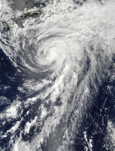
Tropical Storm Yagi is not expected to make landfall in Japan, but NASA satellite imagery showed that the storm was just south of the big island.
NASA's Aqua satellite passed over Tropical Storm Yagi on Tuesday, June 11 at 04:10 UTC (12:10 a.m. EDT/1:10 p.m. Japan local time) and the Moderate Resolution Imaging Spectroradiometer or MODIS instrument captured a visible image of the storm. The image showed that clouds associated with the northern fringes of the storm were draped over southeastern coastal Japan.
The MODIS image also revealed that Yagi has a long "tail" or band of thunderstorms feeding into the center from the south.

NASA's Aqua satellite passed over Tropical Storm Yagi on Tuesday, June 11 at 1:10 p.m. Japan local time and captured this visible image that showed clouds associated with the northern fringes of the storm were draped over southeastern coastal Japan.
(Photo Credit: : NASA Goddard MODIS Rapid Response Team)
Multispectral satellite imagery shows tight bands of thunderstorms wrapping into the center of the storm, although the building of thunderstorms continues to weaken around the center. Vertical wind shear is starting to take a toll on Yagi, according to the Joint Typhoon Warning Center. Northwesterly wind shear has made a slight tilt to the system with the upper-level center displaced about 20 nautical miles east of the low-level center. When the lower and upper level centers of circulation are not "stacked," a tropical cyclone begins weakening.
At 09:00 UTC (5 a.m. EDT/6 p.m. Japan local time) Yagi had maximum sustained winds near 50 knots. Tropical storm force winds extend out 95 miles from the center, making the storm about 200 miles wide. Yagi was centered near 29.2 north and 136.9 east, about 307 miles west-northwest of Chichi Jima, Japan. Yagi was moving to the north-northeast at 17 knots. Yagi is kicking up seas with wave heights topping 21 feet, so the southeastern coast of Japan can expect rough seas until Yagi passes by.
Yagi is forecast to turn to the southeast and move away from Japan over the next couple of days, where it is expected to weaken and dissipate.
Source: NASA/Goddard Space Flight Center