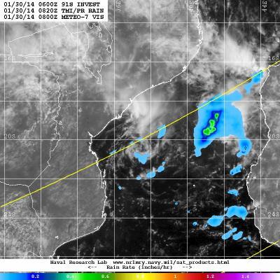
The Tropical Rainfall Measuring Mission or TRMM satellite that observed the tropical low pressure area designated as System 91S earlier this week captured another look at a much weaker storm on January 30. Wind shear has now increased in the region, and the development chances for the tropical low pressure area have dropped.
At 800 UTC/3 a.m. EST, the center of System 91S was located near 18.2 south latitude and 39.1 east longitude, about 370 nautical miles northeast of Maputo, Mozambique (which is in the southernmost part of the country).
TRMM passed over System 91S on January 30 at 0820 UTC/3:20 a.m. EST and captured rainfall data on the low. The heaviest rainfall rates were occurring over the waters of the Mozambique Channel, where rain was falling in one area at about 1 inch/25 mm per hour. Other rainfall from the system was light. The U.S. Naval Research Laboratory overlaid TRMM rainfall imagery on top of visible imagery from Europe's METEO-7 satellite to provide a full picture of the low. The center appeared to be in the western Channel, while the heaviest rainfall was occurring in the eastern Channel.

TRMM passed over System 91S on Jan. 30 at 0820 UTC/3:20 a.m. EST and captured rainfall data on the low. The heaviest rainfall rates were occurring over the waters of the Mozambique Channel (yellow/orange).
(Photo Credit: NASA/NRL/ESA)
Animated multispectral satellite imagery shows that the low-level center is elongating as a result of wind shear. A ridge of high pressure located southwest of System 91S is creating moderate wind shear (20 to 25 knots/37.0 to 46.3 kph/23.0 to 28.7 mph) hampering development.
Forecasters at the Joint Typhoon Warning Center have dropped the chances for System 91S to a low chance for potential for tropical development in the next day or two.
Source: NASA/Goddard Space Flight Center