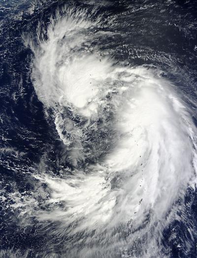
NASA's Terra satellite passed over newborn Tropical Storm Man-yi and captured and image that clearly showed two vortices rotating around a large center of circulation. Man-yi formed on Sept. 12 in the northwestern Pacific Ocean as the sixteenth tropical depression and by Sept. 13 it strengthened into a tropical storm.
When NASA's Terra satellite passed over newborn Tropical Storm Man-yi in the northwestern Pacific Ocean on Sept. 13 at 01:15 UTC, the Moderate Resolution Imaging Spectroradiometer or MODIS instrument captured a visible image of the storm. The MODIS image showed the bulk of clouds and showers on the northwestern and southeastern sides of the storm, but those were associated with the two different vortices or whirling masses of clouds and showers, that are rotating around the storm's actual center. Satellite data showed bands of strong thunderstorms around the southeastern vortex, which is the vortex with the strongest winds. Thunderstorms associated with the northwestern vortex are also strengthening as convection deepens.
Forecasters at the Joint Typhoon Warning Center expect these two different vortices will combine with the larger, broad central circulation, allowing Man-yi to consolidate.

NASA's Terra satellite observed two vortices circling a larger center of newborn Tropical Storm Man-yi on Sept. 13 at 01:15 UTC.
(Photo Credit: Image : NASA Goddard MODIS Rapid Response Team)
On Sept. 13 at 0900 UTC/5 a.m. EDT, Tropical Storm Man-yi had maximum sustained winds near 35 knots/40.2 mph/64.8 kph. It was moving to the west-northwest at 11 knots/12.6 mph/20.3 kph. Man-yi was centered near 22.5 north and 141.0 east, just 157 nautical miles/180.7 miles/290.8 km south of the island of Iwo To, Japan.
Man-yi is expected to intensify to typhoon strength as it curves from northwest to northeast. On the forecast track issued by the Joint Typhoon Warning Center, Man-yi is expected to approach Tokyo on Sept. 16 as a typhoon.
Source: NASA/Goddard Space Flight Center