Tornadoes on February 29 raked through Kansas, Nebraska, Illinois, Indiana, Missouri, Kentucky and Tennessee. The severe storms killed at least 12 people. Tornadoes also touched down in the well-known tourist destination of Branson, Missouri, famous for country music theaters. USA Today reported that up to six of the city's 40 theaters were damaged.
NOAA's Storm Prediction Center reported that tornadoes killed 550 people in the U.S. in 2011.
The cold front associated with the storms that triggered tornadoes on February 29 is over the southeastern and Mid-Atlantic U.S. today, March 1. Another cold front is moving into the areas that experienced severe weather yesterday, and the National Weather Service noted that the south-central U.S. could experience more severe weather today. NOAA's Storm Prediction Center forecasts a moderate chance for severe weather in southwestern Ohio, southeastern Indiana, central Tennessee, and northern Mississippi and northern Alabama. A slight risk of severe weather is forecast in 15 states today, March 1. Thunderstorms are expected from southern New England, through the Ohio and Tennessee Valleys, and as far west as eastern Texas and Missouri today.
As the front moves, the GOES-13 satellite will provide continuous coverage of its movements, providing valuable data to forecasters.
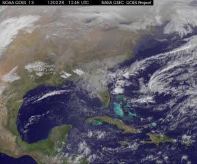
This movie was created using GOES-13 visible and infrared satellite imagery from Feb. 28 at 1245 UTC (7:45 am. EST) through March 1, and shows the progression of the cold front and associated low pressure area moving over the central US that triggered at least 20 tornadoes and severe weather on Feb. 29, 2012.
(Photo Credit: : NASA/NOAA GOES Project)
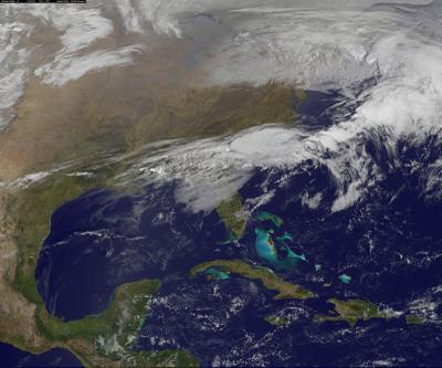
This GOES-13 satellite image was captured on March 1, 2012 at 1301 UTC (8:01 am EST). The clouds associated with the powerful weather front that generated severe storms on Feb. 29, were now located over the southeastern U.S. from eastern Texas, east to the Carolinas. Severe weather is possible again today from the Ohio Valley to the Tennessee Valley and east to the Atlantic Ocean.
(Photo Credit: :NASA/NOAA GOES Project)
Source: NASA/Goddard Space Flight Center