Typhoon Krosa became wide-eyed in imagery from NASA's Aqua satellite as the storm moved past the Philippines and into the South China Sea. Krosa re-strengthened after it passed over the northern Philippines and its eye expanded by 10 nautical miles from the previous day.
NASA's Aqua satellite passed over Krosa on Nov. 5 at 05:05 UTC/1:05 a.m. EDT. Krosa's center had moved over northern Luzon, Philippines and into the South China Sea when Aqua flew overhead. The Moderate Resolution Imaging Spectroradiometer known as MODIS that flies aboard Aqua captured a visible image of the storm revealing the 35-nautical mile-wide/ 40.2 mile/64.8 km eye. The image showed large bands of thunderstorms spiraling into the center of circulation.
On Friday, Nov. 1 at 1500 UTC/11 a.m. EDT, Typhoon Krosa had maximum sustained winds near 85 knots/97.8 mph/157.4 kph. It was centered near 19.5 north and 116.8 east, about 242 nautical miles southeast of Hong Kong, China. It was moving to the west-northwest at 9 knots/10.3 mph/16.6 kph, and generating 30-foot/9.1-meter-high waves in the South China Sea.
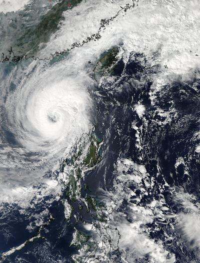
NASA's Aqua satellite passed over Krosa on Nov. 5 at 05:05 UTC/1:05 a.m. EDT and captured Krosa with an expanded eye.
(Photo Credit: Image : NASA Goddard MODIS Rapid Response Team)
Krosa is moving west northwest across the South China Sea and forecasters at the Joint Typhoon Warning Center expect it to turn southwest as it approaches Hainan Island, China on Nov. 3. It is expected to make landfall near Hue, Vietnam on Monday, Nov. 4.
Source: NASA/Goddard Space Flight Center