An animation of NOAA GOES-13 satellite imagery over the days of March 5, 6 and early on March 7 was created by the NASA GOES Project at NASA's Goddard Space Flight Center in Greenbelt, Md. The 24 second animation showed the progression of a cold front from the west associated with a low pressure system that brought snow from Chicago to the Appalachian Mountains. The low merged with a coastal low near the Mid-Atlantic on March 6 and brought up to 2 feet of snow in the Blue Ridge Mountains, while coastal areas and cities including Washington, D.C. and Baltimore received snow followed by heavy rain. The animation ends at 1331 UTC (8:31 a.m. EST) on March 7, when the nor'easter was affecting New England.
According to NOAA's National Operational Hydrologic Remote Sensing Center (NOHRSC) in Chanhassen, Minnesota, who compile and provide interactive snowfall information, the snowfall totals ranged from 18 inches in western northern Virginia to two-tenths of an inch at Reagan National Airport, Washington, D.C.
After the cold front and associated low that swept in from the Upper Mid-west merged with the coastal low pressure area, the coastal low pressure area became the driver. It brought in warmer temperatures from the Atlantic Ocean where sea surface temperatures were in the 40s (Fahrenheit). The warmer air helped keep the precipitation as rainfall in a line from Baltimore and Washington, D.C. eastward. It was the higher elevations in the Mid-Atlantic that saw the most snow.
According to NOHRSC, the Blue Ridge Mountains received the most snow, totaling up to 2 feet. Dulles Airport, Virginia received 3 inches; Blue Mountain, Virginia received 17 inches and Front Royal, Virginia received 12 inches. In Maryland, the city of Westminster which lies west of Baltimore received 4.5 inches, while Columbia, located south of Baltimore, received 2 inches of snow.
The strong winds that accompanied the nor'easter did cause wind warnings and advisories. According to the Baltimore Sun newspaper the winds toppled a tractor trailer truck on Maryland's Bay Bridge that connects to Annapolis. The bridge was closed for four hours. The winds caused tree damage and power outages in Maryland and Delaware. In western northern Virginia and western Maryland winds coupled with heavy, wet snow took down trees and left thousands without power.
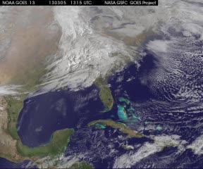
This animation of NOAA GOES-13 satellite imagery from March 5-7, 2013, shows the progression of a cold front from the west associated with a low pressure system that brought snow from Chicago to the Appalachian Mountains. The low merged with a coastal low near the Mid-Atlantic on March 6 and brought more than 18" of snow from western north Virginia and western Maryland into Pennsylvania, while coastal areas and cities including Washington, D.C., and Baltimore received snow followed by heavy rain. The low is affecting New England on March 7.
(Photo Credit: NASA GOES Project)
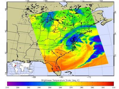
This false-colored infrared image of the Nor'easter from March 6 at 1817 UTC was created from data from the AIRS instrument aboard NASA's Aqua satellite. The dark blue and purple areas indicate the coldest cloud top temperatures with the heaviest precipitation.
(Photo Credit: NASA JPL, Ed Olsen)
Source: NASA/Goddard Space Flight Center