NASA's TRMM satellite captured an image of Cyclone Zane at 11:48 UTC (9:48 p.m. AEST/7:48 a.m. EDT, U.S.) May 1, 2013. At the time, the center of circulation was located about 215 km (~133 miles) due east of the coast of Queensland, Australia and was heading west-northwest. TRMM revealed that Zane was still not very well organized with no eye visible and very little evidence of banding (curvature) in the rain area. At the time of the image, Zane was a Category 1 cyclone (equivalent to a tropical storm on the U.S. Saffir-Simpson scale) with sustained winds reported at 45 knots (~52 mph) by the Australian Bureau of Meteorology's Tropical Cyclone Warning Centre. Most of the rainfall that TRMM measured was light to moderate within Cyclone Zane, with the exception of an area northwest of the center that had a rainfall rate of around 2 inches/50 mm per hour.
This video is a TRMM flyby of Tropical Cyclone Zane in May 2013.
(Photo Credit: NASA)
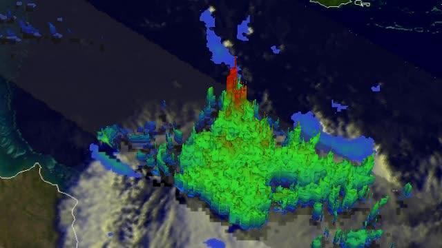
The TRMM data was also made into a 3-D image that showed the cloud heights relative to the rainfall rates occurring in Zane. The image was created at NASA's Goddard Space Flight Center in Greenbelt, Md. and showed that although Zane had an area of active deep convection reaching upwards of 15 km (about 9.2 miles), it was located away from the center of circulation and does not necessarily preclude further strengthening. In fact, Zane weakened further.
By May 1 at 2100 UTC (5 p.m. EDT, U.S.), the Joint Typhoon Warning Center issued their final bulletin on Cyclone Zane. At that time Zane's maximum sustained winds were near 35 knots (40 mph/64 kph) and weakening. Zane was located about 270 nautical miles north-northwest of Cairns, Australia and was moving to the northwest at 10 knots (11.5 mph/18.5 kph).
Zane is expected to weaken due to unfavorable wind shear before crossing the coast of northern Queensland north of the Lockart River and dissipate shortly afterward.
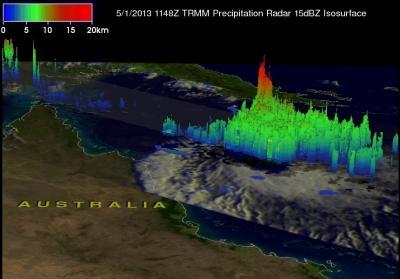
This 3-D picture of Zane from the TRMM PR shows one area of active deep convection reaching upwards of 15 km (shown in red), away from the center of circulation and so does not necessarily preclude further strengthening.
(Photo Credit: NASA/SSAI, Hal Pierce)
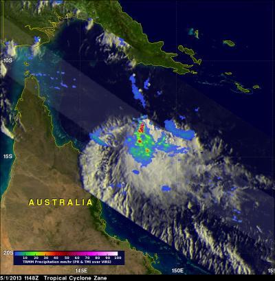
On May 1, NASA's TRMM satellite revealed that Zane was still not very well organized and there was no eye visible and very little evidence of banding (curvature) in the rain area. Heaviest rainfall is in red (about 50 mm/2 inches per hour).
(Photo Credit: NASA/SSAI, Hal Pierce)
Source: NASA/Goddard Space Flight Center