NASA's MASTER instrument captured this infrared composite image of California's Powerhouse Fire. The MASTER image shows the intensity of the heat from the fire in different colors.
The MASTER instrument, also known as the MODIS/ASTER Airborne Simulator that was developed for the Advanced Spaceborne Thermal Emission and Reflection Radiometer (ASTER) and Moderate Resolution Imaging Spectroradiometer (MODIS) projects. ASTER and MODIS are both spaceborne imaging instruments aboard the Terra satellite.
This image is a color composite of three infrared bands from the MASTER instrument, flying at night aboard the NASA ER-2 aircraft on Friday and Saturday night, May 31 and June 1. The pixel resolution is 50 meters (164 feet), and the bands used are Red = 11.3um; Green = 9.1um; and Blue = 4.0um. The hottest part of the wildfire appears in yellow.
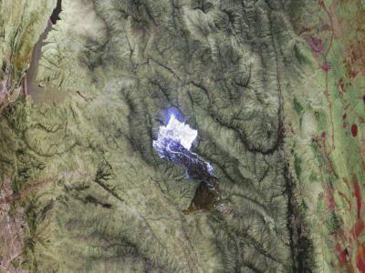
MASTER is a facility instrument of the NASA Earth Science Division, and is operated by the Airborne Sensor Facility at Ames Research Center.
(Photo Credit: Image and caption: NASA Ames Research Center/Jeffrey Myers, Univ. of California, Santa Cruz)
MASTER is a facility instrument of the NASA Earth Science Division, and is operated by the Airborne Sensor Facility at Ames Research Center.
Source: NASA/Goddard Space Flight Center