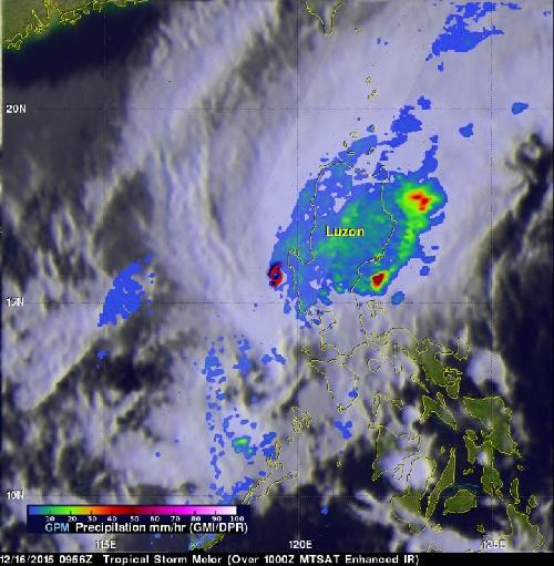
When Tropical Storm Melor was raining on Luzon in the northern Philippines, the GPM satellite analyzed the rainfall rate. The next day, NASA's Terra satellite caught a look at Melor after it moved off-shore and weakened into a trough of low pressure.
NASA and the Japan Aerospace Exploration Agency's Global Precipitation Measurement mission or GPM core observatory satellite had a good view of Tropical Storm Melor on December 16, 2015 at 0956 UTC (4:56 a.m. EST). GPM's Microwave Imager (GMI) and Dual-Frequency Precipitation Radar (DPR) instruments revealed that moisture from Tropical Storm Melor was spreading over the northern Philippine island of Luzon. Very little rain was found at the location of Melor's center of circulation but light to moderate precipitation was shown falling over Luzon. Even more intense showers were seen dropping rain at a rate of over 50 mm (almost 2 inches) per hour off the northeastern coast of Luzon.
The next day, Melor moved away from Luzon and headed in a southwesterly direction in the South China Sea and away from the Philippines. On Dec. 17 at 0300 UTC (Dec. 16 at 10 p.m. EST) Melor was downgraded to a depression. Melor's maximum sustained winds were down to 25 knots (28.7 mph/46.3 kph). At that time it was centered near 12.8 degrees north latitude and 118.5 degrees east longitude, about 145 nautical miles west-southwest of Manila, Philippines. Melor has tracked south-southwestward at 8 knots (9.2 mph/14.8 kph).
 On Dec. 16, GPM saw very little rain near Melor's center and moderate rainfall over Luzon. Rain was falling at a rate of over 50 mm (almost 2 inches) per hour off the northeastern coast of Luzon. Credit: Credit: NASA/JAXA/SSAI, Hal Pierce
The Joint Typhoon Warning Center (JTWC) noted that "animated multispectral satellite imagery and recent microwave imagery showed an open trough (elongated area of low pressure) with no discernable low level circulation center."
On Dec. 17, the Moderate Resolution Imaging Spectroradiometer or MODIS instrument aboard NASA's Terra satellite captured a visible image of the remnants of Tropical Storm Melor, which resembled an elongated low pressure area.
JTWC issued their final bulletin on the storm and said that Melor is not expected to regenerate as the remnants move through the South China Sea.
source: NASA/Goddard Space Flight Center