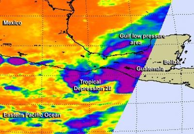
NASA's Aqua satellite captured an infrared image of Tropical Depression 2E that revealed high, very cold cloud top temperatures. Strong thunderstorms with cold cloud top temperatures that reach high into the troposphere have the potential to drop heavy rainfall amounts, and the National Hurricane Center has forecast large rainfall for the southern region of Mexico over the next couple of days.
A Tropical Storm Warning is in effect for Salina Cruz to the Mexico and Guatemala border as the depression remained stationary near the southwestern coast of Mexico on June 3.
NASA's Aqua satellite passed over Tropical Depression 2E on June 3 at 08:17 UTC (4:17 a.m. EDT) and gathered data about the depression's cloud temperatures. The Atmospheric Infrared Sounder (AIRS) instrument that flies aboard NASA's Aqua satellite provided that infrared data. A false-colored image of the cloud temperatures was created at NASA's Jet Propulsion Laboratory (JPL) in Pasadena, California using the infrared data.
The AIRS image showed very cold cloud top temperatures in the depression indicating that the thunderstorms had strong uplift that pushed cloud tops near the top of the troposphere. Temperatures drop to just under 220 degrees kelvin (-63.6 F/-53.1C) at the top of the troposphere (and where the tropopause begins). Some of the depression's storms had cloud tops that cold and that high. An analysis of AIRS data indicated that storms that high in the troposphere have the potential for heavy rainfall.

NASA's Aqua satellite passed over Tropical Depression 2E on June 3 at 4:17 a.m. EDT and gathered data about the depression's cold cloud-top temperatures (purple).
(Photo Credit: Image : NASA JPL, Ed Olsen)
Coupled with the potential for heavy rainfall, and the slow movement of Tropical Depression 2E, the National Hurricane Center (NHC) noted in its bulletin at 8 a.m. EDT (5 a.m. PDT) that rainfall totals may be extreme over a large part of southern Mexico.
According to NHC: tropical Depression 2E is expected to produce as much as 10 to 20 inches of rain over a large part of southern Mexico through Saturday...with isolated amounts exceeding 30 inches likely over the mountainous terrain of the Mexican states of Oaxaca and Chiapas. Tropical Depression 2E is also expected to produce total rainfall amounts of 5 to 10 inches in Guatemala. These rains are likely to result in life-threatening flash floods and mud slides.
At 8 a.m. EDT (5 a.m. PDT), Tropical Depression 2E's maximum sustained winds were near 35 mph (55 kph). It was stationary about 140 miles (220 km) south-southeast of Salina Cruz, Mexico near 14.4 north latitude and 94.3 west longitude. The depression's minimum central pressure was 1002 millibars. NHC expects the depression to being moving slowly northward later today, June 3 and near the coast in the warning area on June 4.
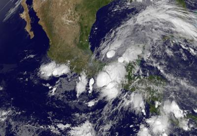
Another factor that hurricane forecasters at NHC are dealing in the forecast of Tropical Depression 2E is the interaction with a low pressure area in the Bay of Campeche on the Gulf of Mexico side of Mexico. The depression is also interacting with an upper-low pressure area as well as the Gulf system, making for a complicated scenario.
Forecaster Blake at the NHC noted during the 8 a.m. EDT discussion that some strengthening is possible before landfall in a day or so, although significant strengthening is not expected due to land interaction and the poor initial structure.

This NOAA GOES-East satellite image from June 3 at 7:45 a.m. EDT shows Tropical Depression 2E interacting with a low pressure area in the southwestern Gulf of Mexico.
(Photo Credit: Image : NASA/NOAA GOES Project)
Source: NASA/Goddard Space Flight Center