Infrared imagery from the AIRS instrument aboard NASA's Aqua satellite revealed that Erick, now a tropical depression has reduced in strength and size and continues to weaken.
The Atmospheric Infrared Sounder or AIRS instrument on NASA's Aqua satellite flew over Tropical Depression Erick late on July 8 and captured an infrared image that revealed Erick was quickly weakening. The AIRS image taken on July 8 at 4:17 p.m. EDT showed a small area of clouds and circulation near the southern tip of Mexico's Baja California peninsula. The strongest thunderstorms with cloud top temperatures as cold as -63F/-52C, were clustered around the low-level circulation center. The National Hurricane Center noted that the strong convection (rising air that forms the thunderstorms that make up a tropical cyclone) has been diminishing greatly since 5 a.m. EDT on July 8.
At 5 a.m. EDT/2 a.m. PDT/0900 UTC, the National Hurricane Center (NHC) reported that Tropical Depression Erick's maximum sustained winds were near 35 mph (55 kph). Erick's center was located near latitude 23.9 north and longitude 112.4 west, about 65 miles (100 km) south of Cabo San Lazaro, Mexico. Erick is moving northwest at 10 mph (17 kph) and is expected to turn west-northwest. The estimated minimum central pressure is 1006 millibars.
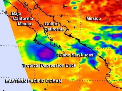
This infrared image from NASA's Aqua satellite taken July 8 at 4:17 p.m. EDT shows Tropical Depression Erick as a small area of clouds (purple and blue) near the southern tip of Mexico's Baja California peninsula.
(Photo Credit: : NASA Goddard MODIS Rapid Response Team)
Because Erick is over cool waters and will be moving over even cooler waters, NHC noted that significant regeneration of deep convection is unlikely. Erick should gradually spin down become a remnant low pressure area later today.
Source: NASA/Goddard Space Flight Center