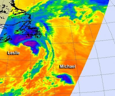
When NASA's Aqua satellite passed over the Atlantic on Sept. 11 it caught Tropical Storm Leslie's clouds over Newfoundland and peanut-shaped Tropical Storm Michael to its southwest. The Atmospheric Infrared Sounder (AIRS) instrument captured infrared data on Tropical Storms Leslie and Michael when it passed overhead on Sept. 11.
Michael Appears Peanut-Shaped on Satellite Imagery
Tropical Storm Michael forecast to become a remnant low later today, Sept. 11, but as of 11 a.m. EDT Michael still had maximum sustained winds near 45 mph (75 kmh). It was located about 1,090 miles (1,755 km) west of the Azores. Michael is moving to the north-northeast 23 mph (37 kmh) and this motion is expected to continue during the next day or so.
In the AIRS infrared image from around 1 a.m. EDT on Sept. 11, the strongest area of convection (and thunderstorms) appeared to be over Michael's north and eastern quadrants making the storm appear peanut-shaped on NASA satellite imagery. An infrared satellite image of Michael later on Sept. 11 showed that most of the convection has disappeared and Michael appeared as tight swirl of low clouds. Michael is over cool waters and in an environment of strong wind shear, two factors that are weakening the storm quickly. The National Hurricane Center forecast notes that Michael's remnants should then become absorbed by a front in the next day or two.

When NASA's Aqua satellite passed over the Atlantic it caught Tropical Storm Leslie's clouds over Newfoundland and Tropical Storm Michael to its southwest, resembling a peanut shape.
(Photo Credit: Ed Olsen, NASA JPL)
Tropical Storm Leslie Moving Away from Newfoundland
According to the Canadian Hurricane Centre, Leslie made landfall Tuesday, Sept. 10 in Fortune, Newfoundland, at about 8:30 a.m. AST (7:30 a.m. EDT) with maximum sustained winds near 40 mph (65 kmh). The Seattle Post Intelligencer newspaper reports power outages and flight cancellations. Canadian Broadcasting Corporation news reported heavy rainfall and wind gusts up to 82 mph (132 kmh) over the Avalon Peninsula, including St. John's that caused power outages, and downed trees. Leslie became a post-tropical cyclone as it begins to move away from Newfoundland.
The Canadian Hurricane Center discontinued the hurricane watch for southeastern Newfoundland early on Sept. 11, but a tropical storm warning is in effect for Newfoundland from Indian Harbour to Triton.
AIRS infrared imagery from 1 a.m. EDT on Sept. 11 showed strong thunderstorms around Leslie's center and in bands to the north of the center. At 11 a.m. EDT on Sept. 11, the center of post-tropical cyclone Leslie was located near latitude 49.4 north, longitude 53.6 west, about 130 miles (210 km) north-northwest of St. Johns Newfoundland. The post-tropical cyclone is moving toward the north-northeast at 45 mph (72 kmh).
By 12 p.m. EDT, satellite imagery showed that Leslie is now part of a cold front and is no longer a tropical cyclone. Post-tropical/extratropical cyclone is still producing a large area of tropical-storm-force winds primarily to the north and east of the center as it continues to move north-northeast at 39 knots. This system is forecast to remain a strong Post-tropical cyclone as it moves rapidly toward the northeast and east over the north Atlantic.
Leslie's remnants are expected to skirt southern Iceland on Thursday, Sept. 12 before heading toward Scotland sometime on Sept. 13.

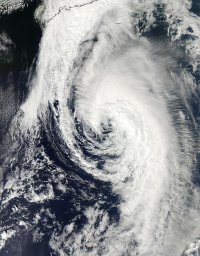
NASA's Aqua satellite passed over Tropical Storm Leslie when it was just south of Nova Scotia, Canada on Sept. 10, 2012 and the MODIS instrument captured this visible image at 1:35 p.m. EDT.
(Photo Credit: NASA/Goddard/MODIS Rapid Response Team)
Source: NASA/Goddard Space Flight Center