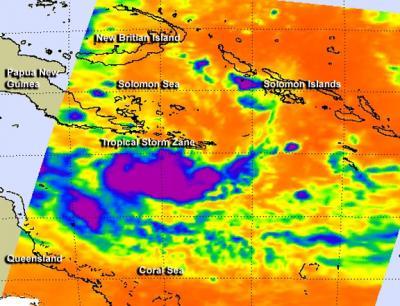
Infrared data indicates temperatures of cloud tops and the surface of the sea beneath tropical cyclones, and NASA's AIRS instrument captured an infrared look at low pressure area System 92P in the Southwestern Pacific Ocean that hinted it was rapidly developing into Tropical Cyclone Zane. Zane is expected to make landfall in northeastern Queensland on May 1 at cyclone strength.
The infrared image of System 92P was taken from the Atmospheric Infrared Sounder (AIRS) instrument aboard NASA's Aqua satellite on April 29 at 1505 UTC (11:05 a.m. EDT). The AIRS data showed that strong convection and thunderstorms were wrapping into the center of circulation in a large band south of the center. The strong thunderstorms in that southern band and around the low pressure area's center of circulation had cloud top temperatures colder than -63 Fahrenheit (-52 Celsius), which indicated they were high in the troposphere and likely dropping heavy rainfall.

This infrared image taken from the AIRS instrument aboard NASA's Aqua satellite on April 30 at 0317 UTC (11:17 p.m. EDT on April 29 shows that the strongest convection and thunderstorms (purple) around the center of circulation as System 92P organized into Tropical Storm Zane.
(Photo Credit: NASA JPL, Ed Olsen)
System 92P went on to consolidate and organize more since the AIRS image and by the early morning hours (EDT) of April 30, the storm strengthened into Tropical Storm Zane. Infrared imagery from AIRS on April 30 indicated a 100 nautical-mile (115.1 mile/185.2 km) diameter central dense overcast feature with a 6-nautical mile (6.9 miles/11.1 km) cloud-filled eye, according to the Joint Typhoon Warning Center. Willis Island radar imagery showed the eye feature with tightly-curved banding over the southern semi-circle.
At 0900 UTC (5 a.m. EDT) on April 30, Tropical Storm Zane was packing maximum sustained winds near 60 knots (69 mph/111 kph), and is expected to strengthen before making landfall on May 1 on the Cape York Peninsula. Zane was located near 14.0 south latitude and 148.8 east longitude, about 135 nautical miles (155.4 miles/250 km) north-northwest of Willis Island, Australia. Zane is moving to the west-southwest at 7 knots (8 mph/13 kph).
Warnings are already in effect for Queensland, Australia as Zane begins its approach. A Cyclone Warning is in effect for coastal areas from Orford Ness to Cape Tribulation. A Cyclone Watch is in effect for coastal areas from Mapoon to Orford Ness, including the Torres Strait Islands.
The forecasters at the Joint Typhoon Warning Center expect Zane to track to the west-northwest and cross the Cape York Peninsula on May 1 and then emerge into the Gulf of Carpentaria. At this time, Zane isn't expected to make a second landfall in Australia and is forecast to pass through the Arafura Sea.

This infrared image taken from the AIRS instrument aboard NASA's Aqua satellite on April 29 at 1505 UTC (11:05 a.m. EDT) shows that the strongest convection and thunderstorms (purple) wrapping into the center of circulation in a large band south of the center.
(Photo Credit: NASA JPL, Ed Olsen)
Source: NASA/Goddard Space Flight Center