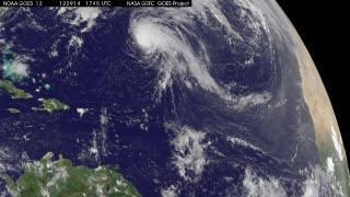
NOAA's GOES-13 satellite sits in a fixed position over the eastern U.S. that allows it to monitor the Atlantic Ocean and it captured a visible image of Tropical Storm Nadine on Sept. 18, 2012 at 10:45 a.m. EDT when it was nearing the Azores. Satellite imagery shows that the strongest convection (rising air that forms the thunderstorms that make up the tropical cyclone) is located north of the center of circulation. NOAA manages the GOES series of satellites, and NASA's GOES Project at the NASA Goddard Space Flight Center in Greenbelt, Md. creates images and animations from the satellite data.
In addition to satellite observations, NASA's Hurricane Severe Storms Sentinel (HS3) Mission plans to send one of the unmanned Global Hawk aircraft to investigate Nadine again on Wednesday, Sept. 19. The Global Hawk investigated Nadine on Tropical Storm Nadine on Sept. 14 and 15. During its 22.5 hour flight around Nadine, the Global Hawk covered more than one million square kilometers (386,100 square miles) going back and forth over the storm in what's called a "lawnmower pattern."
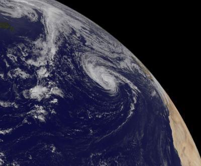
This animation of satellite observations from Sept. 14-18, 2012, shows Tropical Storm Nadine in the central Atlantic. NASA's HS3 Mission Global Hawk investigated Nadine on Tropical Storm Nadine on Sept. 14 and 15. This visualization was created by the NASA GOES Project at NASA Goddard Space Flight Center, Greenbelt, Md., using observations from NOAA's GOES-13 satellite.
(Photo Credit: NASA/NOAA GOES Project)
At 11 a.m. EDT on Sept. 18, Tropical Storm Nadine had maximum sustained winds near 60 mph (95 kph), dropping from 70 mph (100 kph) just 24 hours before. It was located about 410 miles (665 km) southwest of the Azores, near 34.4 North and 32.9 East. Nadine has slowed to about half the speed it was moving on Sept. 17 and is now moving to the northeast near 8 mph (13 kph). Minimum central pressure was near 990 millibars.
As the Azores prepare for Nadine's arrival, ocean swells are expected to affect the islands within the next day or so.
This visible image of Tropical Storm Nadine was captured by NOAA's GOES-13 satellite on Sept. 18, 2012, at 10:45 a.m. EDT when it was nearing the Azores. Newfoundland, Canada is seen in the top left corner and the African coast is seen far right.
(Photo Credit: NASA/NOAA GOES Project)
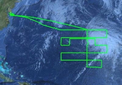
NASA's HS3 Mission Global Hawk investigated Nadine on Tropical Storm Nadine on Sept. 14 and 15. During its 22.5 hour flight around Nadine, the Global Hawk covered more than 386,100 square miles going back and forth over the storm in what's called a "lawnmower pattern."
(Photo Credit: NASA)
Source: NASA/Goddard Space Flight Center