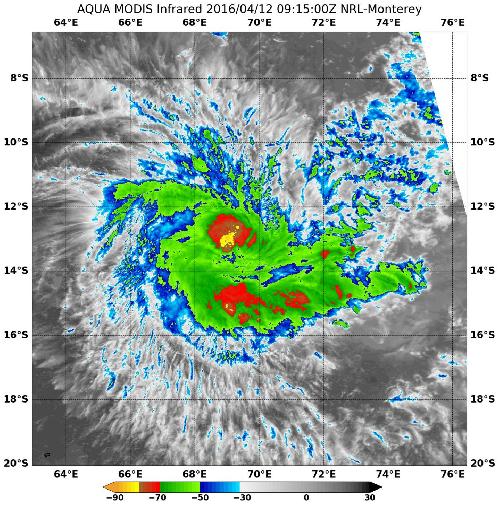
Powerful thunderstorms circled the low-level center of newborn Tropical Cyclone Fantana in infrared imagery from NASA's Aqua satellite.
At 1800 GMT (2 p.m. EDT) on April 11, Tropical Cyclone Fantala formed from System 99S near 13.0 degrees south and 71.2 degrees east in the Southern Indian Ocean. It was 354 nautical miles southeast of Diego Garcia.
At 0900 UTC (5 a.m. EDT) on April 12 Fantala's maximum sustained winds increased to 60 knots (69 mph/111 kph) and it is expected to continue strengthening for the next three days. Fantala was centered near 13.3 degrees south latitude and 69.7 degrees east longitude, about 407 nautical miles south-southwest of Diego Garcia. Fantala was moving to the west at 8 knots (9.2 mph/14.8 kph).
 At 0915 UTC (5:15 a.m. EDT) on April 12 NASA's Aqua satellite gathered infrared temperature data on the clouds within the storm. MODIS found powerful thunderstorms with very cold cloud tops near minus 80 degrees Fahrenheit (minus 62.2 Celsius). Credit: Credits: NASA/NRL
The Joint Typhoon Warning Center noted that animated multispectral imagery showed a developing 15 nautical-mile-wide (17.2 miles/27.7 km) eye. The bulk of the strongest storms were seen in the western quadrant of the storm
At 0915 UTC (5:15 a.m. EDT) the Moderate Resolution Imaging Spectroradiometer or MODIS instrument that flies aboard NASA's Aqua satellite gathered infrared temperature data on the clouds within the storm. MODIS found powerful thunderstorms with very cold cloud tops near minus 80 degrees Fahrenheit (minus 62.2 Celsius).
Fantala is intensifying rapidly as it moves west toward Madagascar. The storm is expected to peak at 120 knots (138 mph/222 kph) after three days.
source: NASA/Goddard Space Flight Center