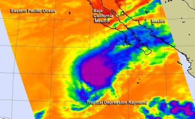
Satellite data shows that the lower level circulation of Raymond decoupled from the middle layer of the storm. When a Tropical Depression decouples, it means the layers of circulation in the atmosphere are no longer "stacked" on top of each other. NASA's Aqua satellite captured infrared data on Raymond that showed the strongest storms, associated with a mid-level circulation center, had broken away from the center.
Think of a tropical cyclone as having several layers of circulation, a lower level, mid-level and upper level. When one of those levels is pushed away from the others, much like pushing the middle of a haystack, the storm weakens. That's what has happened to Raymond.
On Oct. 29 at 4:59 p.m. EDT, NASA's Aqua satellite passed over Raymond, still a tropical storm and the Atmospheric Infrared Sounder or AIRS instrument captured an infrared image. The AIRS images revealed that the coldest cloud top temperatures, and highest, strongest storms were pushed away from the center of circulation. AIRS data also showed some high clouds associated with Raymond were streaming to the east-northeast and over the southern tip of Baja California, Mexico. The image of the AIRS infrared data was created at NASA's Jet Propulsion Laboratory in Pasadena, Calif.
Tropical Storm Raymond weakened to a depression early on Oct. 30 and is expected to dissipate later in the day.

On Oct. 29 at 4:59 p.m. EDT, NASA's Aqua satellite passed over Raymond, still a tropical storm and captured this infrared image of cloud top temperatures, showing the coldest (purple), strongest storms away from its center.
(Photo Credit: Image : NASA JPL, Ed Olsen)
The National Hurricane Center noted that Raymond decoupled over the night of Oct. 29. Satellite data shows that the low-level center was a couple of hundred nautical miles to the southwest the mid-level circulation that includes an area of strong convection (rising air that forms thunderstorms that make up a tropical cyclone). Microwave satellite data also showed that Raymond has elongated, which is another sign of weakening.
To make matters worse for Raymond, its moving into cooler sea surface temperatures and running into dry air - two more factors that will sap its strength.
On Oct. 30 at 5 a.m. EDT/0900 UTC, Tropical Depression Raymond's maximum sustained winds were near 35 mph/55 kph and it was weakening. The center of the depression was located near latitude 19.6 north and longitude 115.7 west, about 440 miles/705 km west-southwest of the southern tip of Baja California. Raymond was moving toward the northeast near 6 mph/9 kph and is expected to turn north while degenerating to a remnant low pressure area.
Source: NASA/Goddard Space Flight Center