A non-tropical low pressure system that has a possibility of developing subtropical characteristics has developed in the Northern Hemisphere tropics. During the week of January 4, Tropical Storm Pali developed in the Northern Central Pacific Ocean. On January 10 an area of low pressure developed in the Northern Atlantic Ocean, far to the east of Bermuda and NASA's Aqua satellite captured a look at the system in infrared light.
NOAA's National Hurricane Center (NHC) noted the development of the extra-tropical low pressure area on Sunday, January 10 at 1:50 p.m. EST. The system was about 900 miles east of Bermuda and is producing a large area of gale-force winds and maximum winds of hurricane force.
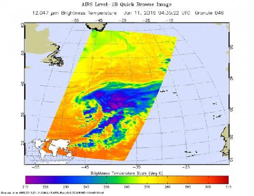
On Jan. 11 at 0435 UTC (Jan. 10 at 11:35 p.m. EST) the Atmospheric Infrared Sounder aboard NASA's Aqua satellite captured infrared data on the system. AIRS provides valuable temperature data such as cloud top and sea surface temperatures. AIRS showed strongest storms with coldest cloud top temperatures near minus 63 degrees Fahrenheit (minus 53 degrees Celsius) east of the center of circulation.
 On Jan. 11 at 0435 UTC, the AIRS instrument aboard NASA's Aqua satellite saw coldest cloud top temperatures near -63F/-53C and strongest storms east of the center in this out-of-season extra-tropical low pressure area. Credit: Credits: NASA JPL, Ed Olsen
By 1200 UTC (7 a.m. EST) the National Weather Service (NWS) High Seas Forecast (HSF) stated that there is an Atlantic Gale Warning in the area of the low pressure system. At that time, the low pressure area was centered just north of 31.5 degrees north latitude and 44 degrees west longitude, about 900 miles southwest of the Azores. Minimum central pressure was near 985 millibars. The NWS HSF said that cold front associated with the system extends from 31 degrees north latitude and 39 west longitude to 25 degrees north latitude and 40 west longitude to 19 degrees north and 50 degrees west to 19 degrees north and 57 degrees west. The clouds along that front are visible in the AIRS infrared image and look like a long tail that extends from the east of the low to the south of the low pressure center.
The National Hurricane Center (NHC) noted at 1400 UTC (2 p.m. EST) that the non-tropical low was producing a large area of gale-force winds with maximum winds near 60 mph. Shower activity was limited near the center, but NHC noted that the low could gradually acquire some subtropical or tropical characteristics during the next couple of days while it moves southeastward and then eastward into the eastern subtropical Atlantic. NHC said over the next 5 days this system has a 40 percent chance of becoming a depression.
NHC said "regardless of subtropical or tropical cyclone formation, this system is expected to produce hazardous marine conditions over portions of the central and eastern Atlantic for the next few days."
source: NASA/Goddard Space Flight Center