NASA's TRMM satellite examined super soaking Super Typhoon Sanba and powerful hot towering thunderstorms around its center and rain falling at a rate as high as three inches per hour.
Kadena Air Base on Okinawa, Japan is on alert as Super Typhoon Sanba approaches. The center of Super Typhoon Sanba is current forecast to come very close to Okinawa on Sept. 15. Today, Sept. 14 at 12 p.m. EDT, Kadena Air Base was on TCCOR 2 alert, which means sustained winds of 50 knots (58 mph) or greater are anticipated within 24 hours.
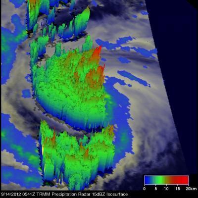
The Tropical Rainfall Measuring Mission (TRMM) satellite flew directly over the clear eye of Super Typhoon Sanba in the western Pacific Ocean on Sept. 14, 2012 at 0541 UTC (1:14 a.m. EDT/2:41 p.m. local time). TRMM's Microwave Imager (TMI) and Precipitation Radar (PR) rainfall data were overlaid on a combination infrared/visible image from the satellite's Visible and InfraRed Scanner (VIRS) at NASA's Goddard Space Flight Center in Greenbelt, Md. to provide a look at the rate rain is falling. The analysis showed that very heavy rain with intensities of over 80 mm (~3 inches) per hour was located in the bands spiraling around the powerful category four typhoon.
TRMM PR data was used to create a 3-D view from the west of Super Typhoon Sanba. The inner eye wall and older eye both extended to heights above 13km (~8.8 miles), that included hot towers.
A "hot tower" is a tall cumulonimbus cloud that reaches at least to the top of the troposphere, the lowest layer of the atmosphere. It extends approximately nine miles (14.5 km) high in the tropics. These towers are called "hot" because they rise to such altitude due to the large amount of latent heat. Water vapor releases this latent heat as it condenses into liquid.
On Sept. 14 at 1500 UTC (11 a.m. EDT) Super Typhoon Sanba's maximum sustained winds were near 135 knots (155 mph/250 kmh). It was located approximately 380 nautical miles (437 miles/704 km) south-southeast of Kadena Airbase, Okinawa, Japan near 20.7 north latitude and 129.6 east longitude. Sanba was moving to the north at 11 knots (12.6 mph/20.3 kmh), and generating extremely rough seas with wave heights up to 53 feet (16.1 kmh).

NASA's TRMM satellite flew directly over the clear eye of Super Typhoon Sanba in the western Pacific Ocean on Sept. 14, 2012 at 1:14 a.m. EDT. TRMM revealed very heavy rain with intensities of over 80 mm (~3 inches) per hour was located in the bands spiraling around the powerful category four typhoon.
(Photo Credit: SSAI/NASA, Hal Pierce)
Satellite imagery on Sept. 14 showed Sanba was tightly wrapped and still has an eye about 13 nautical miles wide. Both TRMM and infrared data from the Atmospheric Infrared Sounder (AIRS) instrument aboard NASA's Aqua satellite shows that most of the showers and thunderstorms associated with Sanba are over the southern semi-circle, and has weakened.
The forecasters at the Joint Typhoon Warning Center noted that wind shear is expected to continue strengthening as Sanba travels into the higher latitudes, which will help weaken the storm. Forecasters expect Sanba to make landfall on the south coast of South Korea on Sept. 17, Monday.

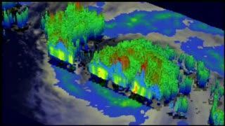
NASA's TRMM satelilte data was used to create this 3-D view flyby of Typhoon Sanba on September 14, 2012, at 0541 UTC. The inner eye wall and older eye are both shown to extend to heights above 13km (~8.8 miles)
(Photo Credit: SSAI/NASA, Hal Pierce)

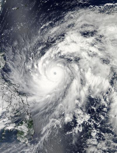
This visible image of Super Typhoon Sanba was captured by the MODIS instrument aboard NASA's Aqua satellite on Sept. 13, 2012 at 0450 UTC (12:50 a.m. EDT).
(Photo Credit: NASA Goddard MODIS Rapid Response Team)
Source: NASA/Goddard Space Flight Center