warnings and high wind warnings remain in effect for parts of the northern Mid-Atlantic into New England as rivers continue to move floodwaters downstream.
NOAA's GOES-13 satellite captured an image of Irene's huge area of remnant clouds and rainfall over northern New England and eastern Canada today at 7:45 a.m. EDT. Her remnants were bringing gusty winds and heavy rainfall on parts of Quebec and in the Maritime provinces. Just as she did in the Caribbean and eastern U.S. Irene is causing a lot of downed trees and power outages. Montreal has reported thousands of outages according to Hydro-Québec.
CBC News reported at 8 a.m. EDT today that Irene was centered about 34 miles (55 kilometers) south-southeast of Baie Comeau, Quebec. Irene is moving toward Labrador. Currently there are wind warnings in effect for Prince Edward Island and portions of Quebec. CBC reported that almost 2 inches (50 millimeters) of rain had fallen in southern New Brunswick by Sunday afternoon and there were over 50,000 residents without electricity there.
On Saturday afternoon August 27, the Tropical Rainfall Measuring Mission (TRMM) satellite provided forecasters with clues that Irene's winds were about to weaken. TRMM, a satellite managed by NASA and the Japanese Space Agency, JAXA flew over Hurricane Irene after it made landfall in North Carolina.
According to Owen Kelley of the TRMM team at NASA's Goddard Space Flight Center, TRMM provided multiple pieces of evidence that showed Irene was weakening at the time: The eye had filled, i.e., there was precipitation inside it; the eyewall contained no regions of heavy precipitation, that was there in earlier images; the eyewall precipitation reached less high in altitude on this overflight than in previous overflights (5.6 miles vs. 7.5 miles) (~9 km vs. ~12 km); and the only lightning observed by the TRMM LIS was in an outer rain band, over 300 kilometers (180 miles) away from the eye. The absence of lightning in the inner core of Hurricane Irene at landfall suggests that the fastest inner-core updrafts were not as vigorous as they had been on previous days.
Below are rainfall totals from Irene's passage, as compiled by the National Hurricane Center.
Rainfall Totals Compiled By NOAA'S National Hurricane Center Selected Storm Total Rainfall in Inches Through 5 Am Edt, August 29, 2011
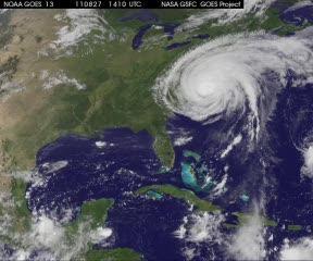
GOES-13 satellite movie shows Hurricane Irene moving through New York, New England and into eastern Canada. The animation runs from August 27, 2011 10:15 a.m. EDT to Aug. 29 at 10:15 a.m. EDT.
(Photo Credit: NASA/NOAA GOES Project, Dennis Chesters)
...CONNECTICUT...BURLINGTON 8.70EAST HARTFORD 8.18MONROE 7.40DANBURY 6.72OXFORD 6.69WEST HAVEN 6.00GREENWICH 6.00
...DELAWARE...ELLENDALE 10.43ADAMSVILLE 10.00MILFORD 9.26DOVER 8.79HARRINGTON 8.75GUMBORO 8.62TOWNSEND 8.34WILMINGTON 6.48
...MASSACHUSETTS...SAVOY 9.10SHELBURNE FALLS 8.50TOLLAND 7.90HEATH 7.70GOSHEN 7.50WESTHAMPTON 7.15MILFORD 6.00
...MARYLAND...PLUM POINT 12.96EASTON 11.34HICKMAN 10.50CALIFORNIA 9.76RIDGE 8.96PATUXENT RIVER 8.15FEDERALSBURG 8.00
...MAINE...PHILLIPS 6.11ANDOVER 5.96
...NORTH CAROLINA...BUNYAN 15.66NEW BERN 14.79WILLIAMSTON 14.27WASHINGTON 13.11GREENVILLE 12.32JACKSONVILLE 11.70CROATAN FOREST 11.13HAVELOCK 10.70HOLLY SHELTER 8.26SOUTHPORT 7.84WILMINGTON 7.60ELIZABETH CITY 7.50
...NEW HAMPSHIRE...SANDWICH 6.09WASHINGTON 6.00NORTH WEARE 5.37
...NEW JERSEY...STOCKTON 10.32WAYNE 10.20ORANGE 9.96PETERSBURG 9.52NEWARK 8.92SOMERDALE 8.60ESTELL MANOR 8.57HEISLERVILLE 8.50WINDSOR 8.40TETERBORO 8.22SOMERVILLE 7.29WOODSTOWN 6.98PLAINSBORO 6.73
...NEW YORK...TUXEDO PARK 11.48HARRIMAN 10.45SUMMIT 8.88LIVINGSTON 8.26HUDSON 7.05NYC CENTRAL PARK 6.87NORTHPORT 6.78GRAVESEND 6.78
...PENNSYLVANIA...LAFAYETTE 8.82FORKS TWP 8.53EXTON 7.83WEST CHESTER 7.46SPRINGTOWN 7.26ASTON TWP 6.79KING OF PRUSSIA 6.71MORGANTOWN 6.21PHILADELPHIA 5.70
...RHODE ISLAND...WARREN 5.37
...VIRGINIA...SUFFOLK 11.04NEWLAND 10.50WAKEFIELD 9.25NORFOLK 8.73NASA Wallops reports on Twitter that 8.6 inches of rain have fallen at the main base with winds reaching 65 miles per hour (mph).WILLIAMSBURG 8.21PORTSMOUTH 7.82GWYNNS ISLAND 7.27SANDSTON 6.38NEWPORT NEWS 6.23
...VERMONT...WALDEN 7.60RANDOLPH CENTER 7.15LUDLOW 6.61WOODFORD 6.58WARREN 5.75CHELSEA 5.25
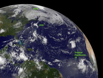
This GOES-13 image from Monday, Aug. 29 at 7:45 a.m. EDT shows an active Atlantic Ocean with the remnants of Hurricane Irene moving into Quebec and Newfoundland (left), Tropical Storm Jose (center) and newly formed Tropical Depression 12 (right).
(Photo Credit: NASA/NOAA GOES Project)
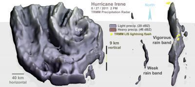
On Saturday afternoon Aug. 27, NASA's TRMM satellite flew over Hurricane Irene. This image shows the 3D volume of rainfall inside Irene's clouds after recently making landfall in North Carolina. The large region of rainfall near the eye (on the left of the image) was over N.C. Several rain bands existed hundreds of kilometers (100 to 200 miles) to the east over the Atlantic Ocean, as seen on the right side of the image.
(Photo Credit: NASA, Owen Kelley)
Source: NASA/Goddard Space Flight Center