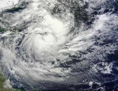
The twenty-third tropical cyclone of the Southern Pacific tropical cyclone season has developed near the Solomon Islands and strengthened into Tropical Storm Ita on April 5. NASA satellite imagery showed the center of circulation just southwest of Sudest Island. Sudest is a volcanic island within Milne Bay Province of Papua New Guinea.
On April 5 at 2100 UTC/5:00 p.m. EDT, Ita formed in the Coral Sea, about 599 nautical miles east-northeast of Cairns, Australia, and was moving to the west-southwestward at 5 knots/5.7 mph/9.2 kph. At that time, maximum sustained winds were near 45 knots/51.7 mph/83 kph.
Satellite data on April 5 showed that strong convection (and developing thunderstorms) were along both the southern and eastern quadrants of the newborn storm.

NASA's Terra satellite MODIS instrument captured this image of Tropical Cyclone Ita on April 6. The image shows strong thunderstorms surrounding the tightly-wrapped center of circulation, just southeast of Sudest Island.
(Photo Credit: Image : NASA Goddard MODIS Rapid Response Team)
On April 6, when NASA's Terra satellite passed over Ita the Moderate Resolution Imaging Spectroradiometer (MODIS) instrument captured a visible image of the storm. The image was created by NASA's MODIS Rapid Response Team at the NASA Goddard Space Flight Center in Greenbelt, Md. The MODIS image showed strong thunderstorms surrounding the tightly-wrapped center of circulation, just southeast of Sudest Island. Bands of thunderstorms were wrapping into the center from the north and east, and from the southwest.
At 1200 UTC/8 a.m. EDT/10 p.m. local time (Brisbane/Australia) on April 7, Tropical Cyclone Ita was located over the northern Coral Sea near latitude 12.1 south and longitude 153.4 east, about 532 nautical miles/612.2 miles/985.3 km northeast of Cairns, Queensland. Maximum sustained winds were near 45 knots/51.7 mph/83.3 kph.
The Joint Typhoon Warning Center (JTWC) expects Ita to move to the west then southwest over the next several days. JTWC forecasters expect Ita to make landfall in the northeastern Cape York Peninsula of Queensland, Australia around April 11. Currently there are no watches posted yet, but the Australian Bureau of Meteorology noted that Ita could begin affecting the Queensland coast on Wednesday, April 9.
Source: NASA/Goddard Space Flight Center