Tropical storm Hagibis only lived through 6 bulletins issued by the Joint Typhoon Warning Center in its short lifetime in the northwestern Pacific Ocean. The final bulletin was issued on June 15 at 1500 UTC (11 a.m. EDT) after Hagibis made landfall in China.
Hagibis was born in the South China Sea on June 14 at 0900 UTC (5 a.m. EDT) near 20.7 north latitude and 117.0 east longitude, about 183 nautical miles east-southeast of Hong Kong when a low pressure system quickly consolidated and maximum sustained winds jumped to 35 knots (40 mph/62 kph). Hagibis is the seventh tropical depression of the Northwestern Pacific Ocean hurricane season. By the morning hours of June 15 Hagibis' maximum sustained winds peaked at 40 knots (46 mph/74 kph) as it neared China's coast.
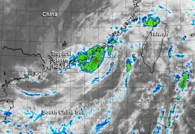
As Hagibis was making landfall, NASA's Terra satellite passed overhead in its orbit around the Earth. The Moderate Resolution Imaging Spectroradiometer or MODIS instrument aboard Terra captured an infrared image at 14:15 UTC (12:15 p.m. EDT) that showed the storm making landfall on the coast of Haojiang District of Shantou City in China's Guangdong Province.

NASA's Terra satellite captured an infrared image at 14:15 UTC of Hagibis making landfall on the coast of Haojiang District of Shantou City in China's Guangdong Province.
(Photo Credit: Image : NRL/NASA)
By 1500 UTC (11 a.m. EDT) on June 15, Hagibis was centered near 23.5 north latitude and 116.5 east longitude, about 146 nautical miles (168 miles/270.4 km) east-northeast of Hong Kong. Hagibis made landfall with maximum sustained winds near 35 knots (40 mph/62 kph).
Hagibis brought heavy rainfall to the Fujian and Guangdong provinces. According to a report from Xinhuanet, Hagibis dropped as much as 302 mm (11.8 inches) of rain in Guangdong province. Later in day, Hagibis dissipated over mainland China.
Source: NASA/Goddard Space Flight Center