The ninth tropical cyclone of the Southern Indian Ocean season was born hours after NASA's Aqua satellite passed overhead and gathered important infrared data on the developing storm.
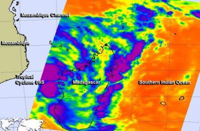
NASA's Aqua satellite passed over System 95S on January 15 at 21:59 UTC/4:59 p.m. EST and saw two large areas of powerful thunderstorms within the developing low pressure area. Thunderstorms with cloud top temperatures exceeding -63F/-52C indicated powerful uplift in the low pressure area.
System 95S consolidated and organized more by 1500 UTC/10 a.m. EST on January 16 to be classified as Tropical Cyclone 09S. At that time, 09S was centered near 20.2 south latitude and 43.4 east longitude, about 215 nautical miles/247.4 miles/398.2 km west-southwest of Antananarivo, Madagascar, and just off the west coast of Madagascar, over the southern Mozambique Channel. The channel is an area of water that lies between the island nation of Madagascar and the country of Mozambique on the African Continent. Tropical Cyclone 09S was moving to the southwest at 10 knots/11.5 mph/18.5 kph and had maximum sustained winds near 35 knots/40 mph/62 kph.

NASA's Aqua satellite passed over System 95S on January 15 at 4:59 p.m. EST and saw two large areas of powerful thunderstorms (purple) within the developing low pressure area.
(Photo Credit: Image : NASA JPL, Ed Olsen)
Forecasters at the Joint Typhoon Warning Center expect 09S to strengthen to 50 knots/57.5 mph/92.6 kph and turn to the northwest, bringing gusty winds and rainfall from southeastern to east-central Mozambique over the next several days. By January 21, Tropical Cyclone 09S is expected to make landfall in east central Mozambique near Quelimane.
Source: NASA/Goddard Space Flight Center