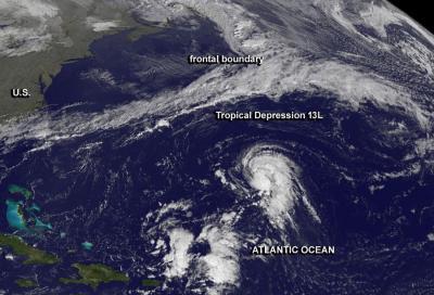
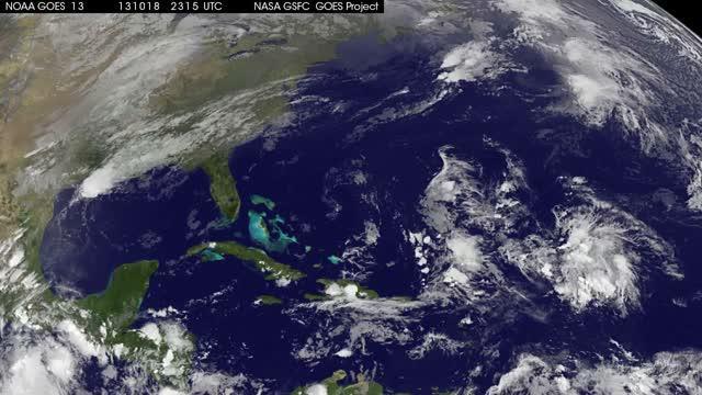
The thirteenth tropical depression of the Atlantic Ocean season formed today, Oct. 21 and NOAA's GOES-East satellite captured its development. NASA's GOES Project created an animation from the NOAA satellite imagery that shows the depression's development over three days.
On Oct. 21 at 11 a.m. EDT/1500 UTC, Tropical Depression 13L was born about 650 miles/1,045 km east-southeast of Bermuda near 28.0 north and 55.1 west. It had maximum sustained winds near 35 mph/55 kph and some strengthening is expected. Tropical Depression 13L is moving to the northeast at 8 mph/13 kph and is expected to continue for a day before turning to the east-northeast.
In a 29 second animation of GOES-East satellite imagery from Oct. 19 through 21, the formation of the depression can be seen over 600 miles east-southeast of Bermuda. The animation was created by the NASA GOES Project at NASA's Goddard Space Flight Center in Greenbelt, Md.
Forecasters at the National Hurricane Center noted that satellite imagery showed a long curved band of thunderstorms over the eastern semicircle of the center of circulation. There is also a small cluster of convection (rising air that forms thunderstorms that make up the tropical cyclone) on the east side of the low-level center.
Forecasters at the National Hurricane Center expect the depression to strengthen into a tropical storm. If it does become a tropical storm it would be named "Lorenzo."

GOES-East image of Tropical Depression 13L on Oct. 21 at 11:45 UTC/7:45 a.m. EDT in the central Atlantic Ocean.
(Photo Credit: Image : NASA GOES Project)

This animation of GOES-East satellite imagery from Oct. 19 through 21 shows the development of Tropical Depression 13L in the Atlantic (far right), about 650 miles east-southeast of Bermuda.
(Photo Credit: Image : NASA GOES Project)
Source: NASA/Goddard Space Flight Center