When the TRMM satellite flew over Cristina on June 11, 2014 at 1142 UTC (4:42 a.m. PDT) it was a hurricane. A rainfall analysis that used data from TRMM's Microwave Imager (TMI) and Precipitation Radar (PR) instruments was overlaid on an enhanced infrared image received by NOAA's GOES-East satellite at 1145 UTC (7:45 a.m. EDT) to provide a complete picture of the hurricane's cloud extent and rainfall rates. The TRMM TMI data clearly revealed that an eye had developed indicating that Cristina was definitely a hurricane. TRMM PR found that rain was falling at a rate of over 74.4 mm (2.9 inches) per hour in a strong feeder band east if Cristina's eye. Another smaller area of strong convective thunderstorms west of Puerto Vallarta, Mexico was also found to contain very heavy rainfall with the tallest thunderstorm tops reaching heights of about 16.5km (10.2 miles).
Later on June 11, at 19:59 UTC (3:59 p.m. EDT) when NASA's Aqua satellite passed over Hurricane Christina as it was rapidly intensifying, the Atmospheric Infrared Sounder (AIRS) instrument gathered infrared data on the cloud top temperatures of the storm. By early morning on June 12, Cristina had a circular central dense overcast with very cold cloud tops near -80C (-112F).
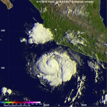
On June 11, NASA's TRMM satellite found rain falling at a rate of over 74.4 mm/2.9 inches per hour in a strong feeder band east of Hurricane Cristina's eye.Another area of thunderstorms west of Puerto Vallarta, Mexico had heavy rain and cloud tops reaching heights of about 16.5km (about 10.2 miles).
(Photo Credit: Image : NASA/SSAI, Hal Pierce)
At 11 a.m. EDT (8 a.m. PDT) on June 12, Hurricane Cristina's maximum sustained wind were near 150 mph (240 kph). Cristina was about 250 miles (400 km) southwest of Manzanillo, Mexico, near latitude 16.6 north and longitude 107.1 west. Cristina was moving toward the west-northwest near 8 mph (13 kph) and a northwestward to west-northwestward motion is expected through Saturday morning (June 14).The estimated minimum central pressure is 935 millibars.
The NHC said that light vertical wind shear and a deep warm ocean should allow Cristina to maintain major hurricane strength for another 36 hours.
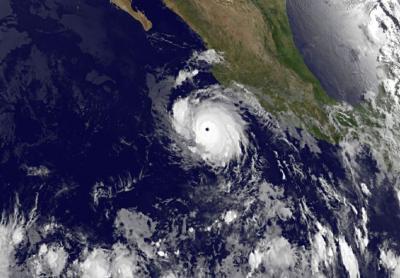
This infrared image of Category 4 Hurricane Cristina was taken by NOAA's GOES-West satellite on June 12 at 1200 UTC (8 a.m. EDT). Cristina has a very clear, distinct eye.
(Photo Credit: Image : NASA/NOAA GOES Project)
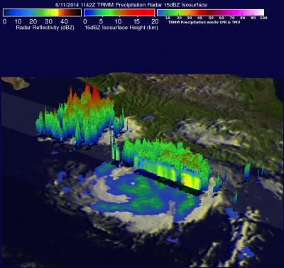
On June 11, NASA's TRMM satellite found rain falling at a rate of over 74.4 mm/2.9 inches per hour in a strong feeder band east of Cristina's eye. Another area of thunderstorms west of Puerto Vallarta had heavy rain and thunderstorm tops reaching heights of about 16.5km (about 10.2 miles).
(Photo Credit: Image : NASA/SSAI, Hal Pierce)
Source: NASA/Goddard Space Flight Center