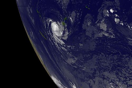
Tropical Storm Ula continued to weaken as it pulled farther away from Fiji in the Southern Pacific Ocean. NASA's RapidScat instrument found that the strongest winds in the storm were south of the center. NOAA's GOES-West satellite captured an infrared image of the storm that showed stronger thunderstorms had recently developed around its center.
On Jan. 7, 2016 NASA's RapidScat instrument measured surface winds in Tropical Storm Ula and saw the strongest sustained winds near 29 meters per second//64.4 mph/104.4 kph south of the center. Maximum sustained winds are not always equally distributed in a hurricane or tropical storm, winds in the other quadrants were not as strong. RapidScat instrument helps forecasters find the strongest quadrants of a storm. RapidScat is an instrument that flies aboard the International Space Station.
NOAA's GOES-West satellite captured an infrared image of Tropical Storm Ula at 1200 UTC (7 a.m. EST) on Jan. 7, 2016. The infrared image showed that stronger thunderstorms redeveloped in the center of circulation as wind shear relaxed and the storm moved over warmer sea surface temperatures.
 This image from NOAA's GOES-West satellite on Jan. 7, 2016 at 1200 UTC (7 a.m. EST) shows Tropical Storm Ula in the South Pacific Ocean west-southwest of Fiji. Credit: Credits: NASA/NOAA GOES Project
At 0900 UTC (4 a.m. EST) on Jan. 6, 2016 Ula's maximum sustained winds had dropped to 45 knots (51 mph/83 kph). Ula continues to track to the northwest at 4 knots (4.6 mph/7.4 kph) and into increasing vertical wind shear, which is expected to keep weakening the storm. Ula was centered near 19.0 degrees south latitude and 175.0 degrees east longitude, about 201 nautical miles (231.3 miles/372.3 km) west-southwest of Suva, Fiji.
The Joint Typhoon Warning Center forecast calls for Ula move toward the northwest and re-strengthen for a day or two before the storm turns to the southwest where it will run into increasing vertical wind shear and move back over cooler waters. Both of those factors are expected to weaken the storm and lead to dissipation by Jan. 10, 2016.
NASA's Goddard Space Flight Center
source: NASA/Goddard Space Flight Center