Super Typhoon Hagupit is forecast to make landfall in the eastern Philippines bringing heavy rainfall, damaging winds and storm surge. NASA/JAXA's TRMM satellite and the RapidScat instrument provided rainfall and wind data, while NASA-NOAA's Suomi NPP satellite provided a visible image of the storm. In the Philippines, Hagupit is known locally as "Typhoon Ruby."
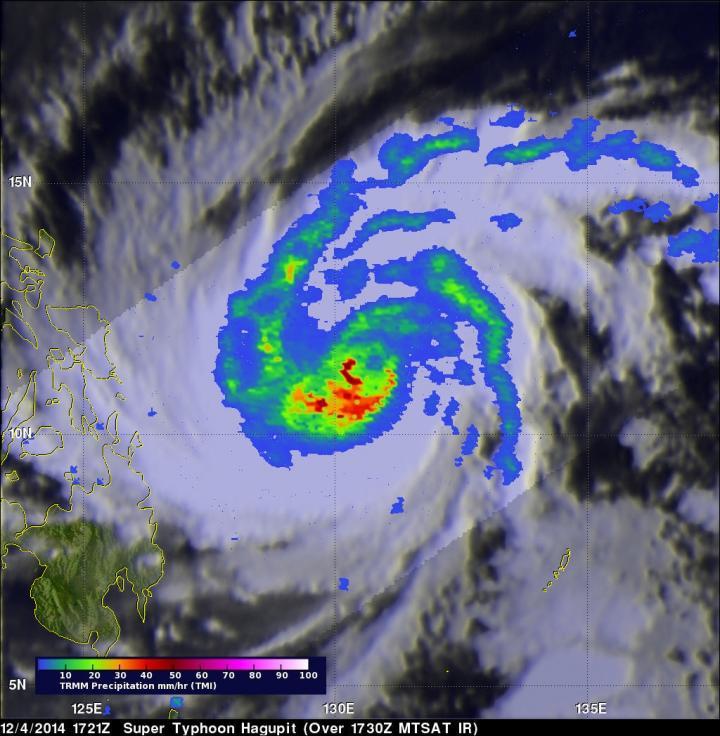
The Tropical Rainfall Measuring Mission or TRMM satellite caught a good view of Super Typhoon Hagupit on December 4, 2014 at 1721 UTC (12:21 p.m. EST) when its sustained winds were estimated at over 145 knots (166.8 mph). TRMM's Microwave Imager (TMI) showed that the heaviest rainfall was just southwest of a well-defined eye.
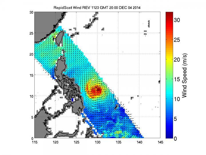
About three hours later the International Space Station-RapidScat instrument captured data on Hagupit's winds. The RapidScat image showed sustained winds of at least 30 meters per second (67 mph/108 kph) around the eye of the storm.
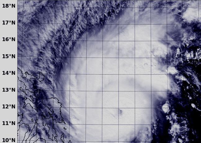
NASA-NOAA's Suomi NPP satellite flew over Super Typhoon Hagupit on Dec. 5 at 4:22 UTC (Dec. 4 at 11:22 p.m. EDT) and the Visible Infrared Imaging Radiometer Suite or VIIRS instrument aboard captured a visible image of the storm. The VIIRS image showed a symmetric ring of intense thunderstorms surrounding the 12-nautical-mile-wide eye.

This TRMM satellite image of Super Typhoon Hagupit on Dec. 4, 2014 at 1721Z showed that the heaviest rainfall was just southwest of a well-defined eye.
(Photo Credit: Image : NASA/JAXA/SSAI, Hal Pierce)
VIIRS is a scanning radiometer that collects visible and infrared imagery and "radiometric" measurements. Basically it means that VIIRS data is used to measure cloud and aerosol properties, ocean color, sea and land surface temperature, ice motion and temperature, fires, and Earth's albedo (reflected light).
At 1500 UTC (10 a.m. EST) on Dec. 5, Super Typhoon Hagupit's maximum sustained winds were near 130 knots (149.6 mph/241 kph), down from 150 knots (172 mph/277.8 kph). Typhoon-force winds extend out 40 nautical miles (46 miles/74 km) from the center, while tropical-storm-force winds extend out to 120 miles (138 miles/222 km).
Hagupit was centered near 12.1 north longitude and 128.2 east latitude, about 465 nautical miles (535 miles/861 km) southeast of Manila, Philippines. Hagupit continued moving in a west-northwesterly direction. The storm is generating very rough and dangerous seas with wave heights to 45 feet (13.7 meter).
According to the Joint Typhoon Warning Center (JTWC) forecast, Super Typhoon Hagupit will "maintain intensity until it starts interacting with land near 24 hours (1500 UTC/10 a.m. EST on Dec. 6) then the system will begin rapidly weakening."
Many warnings are in effect throughout the Philippines. Public storm warning signal #2 is in effect in the following provinces: Visayas: Northern and eastern Samar, Samar, Biliran, Leyte, southern Leyte, northern Cebu and Cebu City, Bantayan Island and Camotes Island. In Luzon, signal #2 is in effect for: Albay, Sorsogon, Ticao Island and Masbate.

NASA-NOAA's Suomi NPP satellite flew over Super Typhoon Hagupit on Dec. 5 at 4:22 UTC (Dec. 4 at 11:22 p.m. EDT) and the VIIRS instrument showed the 12 mile-wide eye.
(Photo Credit: Image : NASA/NOAA)
Public storm warning signal #1 is in effect in the Province of Visayas including: Capiz, Iloilo, Antique, Guimaras, Aklan, Negros Oriental & Occidental, rest of Cebu, Siquijor and Bohol. Signal #1 is also in effect in the Mindanao Province for Surigao del Sur, & Norte, Misamis Oriental, Agusan del Sur & Norte, Dinagat Island and Camiguin Island; and in the Province of Luzon, including: Catanduanes, Camarines Norte & Sur, Burias Island and Romblon.
On Dec. 5 at 10 a.m. EST (1500 UTC) the latest update from the Philippine Atmospheric, Geophysical and Astronomical Services Administration known as PAGASA called for expected landfall on Saturday evening (Dec. 6) or Sunday morning (Dec. 7) over the Eastern Samar - Northern Samar area and it will be associated with strong winds, storm surge (up to 4 meters) and heavy-intense rainfall.
PAGASA noted:
- "Estimated rainfall amount is from 7.5 - 20 mm per hour (heavy - intense) within the 600 km diameter of the typhoon.
- Ruby (Hagupit) and the Northeast Monsoon will bring rough to very rough sea conditions over the seaboards of Northern Luzon, eastern seaboard of Central and Southern Luzon, seaboards of Visayas and over northern and eastern seaboards of Mindanao. Fishermen and those using small seacraft are advised not to venture out over the said seaboards."

Station-RapidScat instrument captured data on Hagupit's winds. The RapidScat image showed sustained winds of at least 30 meters per second (red) around the eye of the storm.
(Photo Credit: Image : NASA JPL)
Source: NASA/Goddard Space Flight Center