Typhoon Phanfone packed heavy rainfall as it brushed over Japan and NASA's TRMM satellite identified where the rain fell. That data was used to make a map of rainfall totals.
The Tropical Rainfall Measuring Mission or TRMM satellite has the ability to calculate rainfall rates within storms as it orbits around the Earth's tropics from space. TRMM data can also be used to create rainfall maps that show how much rain has fallen over given areas.
Phanfone was a powerful super typhoon with sustained wind speed estimated at 130 knots (150 mph) as it approached Japan but had weakened to a category one typhoon with sustained winds of about 70 knots (81 mph) as is passed near Tokyo.
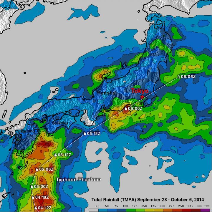
Typhoon Phanfone dropped rainfall over much of Japan but rainfall was particularly heavy near Phanfone's track along the southeastern coast of the islands. Phanfone's track and locations are shown overlaid in white.
(Photo Credit: Image : SSAI/NASA, Hal Pierce)
The TRMM- based, near-real time Multi-satellite Precipitation Analysis (TMPA) conducted at the NASA Goddard Space Flight Center in Greenbelt, Maryland has been measuring the distribution of precipitation over the tropics since TRMM's launch in 1997.
TMPA based rainfall totals were calculated for the period from September 28 to October 6, 2014 during which Phanfone formed east of Guam and traveled to Japan. The typhoon dropped rainfall over much of Japan but rainfall was particularly heavy near Phanfone's track along the southeastern coast of the islands. The analysis indicated that Phanfone dropped the greatest amount of rainfall in central Japan west of Tokyo where rainfall totals greater than 275 mm (10.8 inches) were found. This analysis found some rainfall totals above 300 mm (11.8 inches) over the Pacific Ocean southeast of Japan.
Source: NASA/Goddard Space Flight Center