On Oct. 3 at 11 a.m. EDT, Tropical Storm Nadine had maximum sustained winds near 50 mph (85 kmh). It was centered about 405 miles (650 km) west-southwest of the Azores near latitude 35.1 north and longitude 33.3 west. Nadine was moving to the east at 14 mph (22 kph), and had a minimum central pressure of 1000 millibars.
Some weakening is forecast during the next two days, but Nadine is expected to still be a tropical storm when the center moves near or over the Azores, according to the NHC.
Nadine is battling wind shear and cooler sea surface temperatures, two factors that will make the storm transition into an extra-tropical cyclone. Wind shear is so strong over Nadine that the strongest thunderstorms and rainfall are pushed northeast of the center. The NHC forecast calls for Nadine to most likely become a post-tropical cyclone by Oct. 5 or sooner, before it becomes absorbed by a large extra-tropical cyclone.
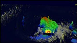
On Oct. 2 at 11:43 p.m. EDT, heavy convective thunderstorms were found in Nadine's northeastern quadrant by NASA's Tropical Rainfall Measuring Mission (TRMM) satellite. Wind shear had separated the center of circulation from this convective activity so, TRMM found virtually no rainfall near Nadine's center. TRMM's Precipitation Radar data reveal in this 3-D image that Nadine's vertical structure had changed significantly by wind shear since yesterday (Oct. 2, 2012). Powerful convective storms northeast of the center of circulation were still pushing to heights of about 12km (~7.5 miles).
(Photo Credit: SSAI/NASA, Hal Pierce)
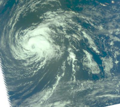
NASA's Aqua satellite passed over Tropical Storm Nadine on Oct. 2 at 11:57 a.m. EDT and saw the strongest thunderstorms north and east of the center of circulation. Near-infrared data, which appears more like a visible image, still showed an eye-like feature.
(Photo Credit: NASA JPL/Ed Olsen)
Source: NASA/Goddard Space Flight Center