Inciweb.org reports, "The Mountain Fire started at 1:43 PM on July 15, 2013 near the junction of Highway 243 and Highway 74. It is currently burning east of the Mountain Center and Apple Canyon Areas. It is burning in very steep and rugged terrain in the southern portion of the San Jacinto Wilderness along the Desert Divide and in the Apple Canyon and Bonita Vista Areas. Some residences and commercial buildings have been destroyed by the fire, though firefighters were able to defend and save a larger number of homes.
Mandatory evacuation orders are in place for Andreas Canyon Club, which are the 24 homes south of Palm Canyon Drive in Palm Springs.
Currently there are 2241 firefighters, including 98 engines, 15 helicopters, 10 fixed wing aircraft, including a DC-10, 73 hand-crews, 6 water-tenders, and 10 dozers fighting this fire.
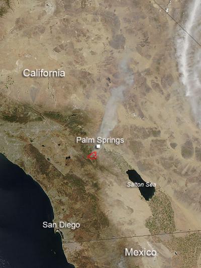
This natural-color satellite image was collected by the Moderate Resolution Imaging Spectroradiometer (MODIS) aboard the Aqua satellite on July 16, 2013. Actively burning areas, detected by MODIS's thermal bands, are outlined in red.
(Photo Credit: NASA image courtesy Jeff Schmaltz, MODIS Rapid Response Team. Caption: NASA/Goddard, Lynn Jenner with information from inciweb.org)
This natural-color satellite image was collected by the Moderate Resolution Imaging Spectroradiometer (MODIS) aboard the Aqua satellite on July 16, 2013. Actively burning areas, detected by MODIS's thermal bands, are outlined in red.
Source: NASA/Goddard Space Flight Center