Human activities continue to expand. At the same time, an increasing number of plants face habitat loss and fragmentation. In fact, more than 700 plants are classified as endangered in the United States.
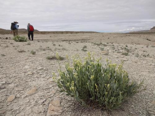
One such plant is the shrubby reed-mustard. Natural gas and oil extraction projects have increased in Northeastern Utah where the plant grows. The construction of roads and well pads has fragmented shrubby reed-mustard habitats. The species is at risk for extinction.
Plants provide us with vital resources such as food and medicines. They also reduce soil erosion and filter ground water. "We need to protect plant biodiversity to maintain ecosystems. Conserving rare plants like the shrubby reed-mustard is an important part of that effort," says Janis Boettinger. Boettinger is a soil scientist at Utah State University.
 Janis Boettinger and Vance Almquist search for shrubby reed-mustard plants at Big Pack Mountain. Credit: Photo credit Julie B. Baker.
Part of the challenge is not knowing exactly where the plants grow. To help, researchers at Utah State University developed a computer model. This model uses satellite imagery and elevation data to better understand where shrubby reed-mustard grows. It can also identify potential new habitats for this endangered plant.
Most of us are familiar with models. Researchers use models to predict everything from weather patterns and sports wins to stock market performance and voting results. Models are collections of information, layered like Lego blocks. For example, local weather reports use wind direction, humidity, and other weather patterns. The information reveals trends and can predict future results.
For the shrubby reed-mustard plant, soil data turns out to be a major building block in predicting habitat.
"Our idea was to find large-scale information -- such as soil color -- from pre-existing satellite maps and digital databases. We could then connect to the known locations of shrubby reed-mustard plants," says Boettinger.
The researchers already had GPS information for a number of sites where the plants were growing. Using satellite maps provided more visual clues. "We found that some of the soil characteristics where shrubby reed-mustard plants grow have a visual component that shows up on the satellite images," says study co-author Brook Fonnesbeck.
Shrubby reed-mustard plants only grow in lighter-colored shale soils of a unique rock formation. Surrounding soils without the plants are much redder and darker sandstone soils.
The researchers also visited several locations where shrubby reed-mustard plants grow. They noted surface features. They also measured soil characteristics.
Researchers layered on-site measurements with GPS and satellite information. This built the model to predict where other shrubby reed-mustard plants grow.
"With this model we can look at large areas very quickly," says study co-author Julie Baker. Baker is a soil scientist at USDA Natural Resources Conservation Service. That's vital because the shrubby reed-mustard often grows in remote and rugged areas that are difficult to reach or survey.
The model worked with an accuracy of almost 70%. And the remaining 30%? "We were often very close to the presence of shrubby reed-mustard," says Boettinger, "but the satellite images didn't have the spatial resolution to be exact."
These models can provide an important tool for land managers. "It will help focus time, labor, and monetary efforts into areas with greater potential for success," Boettinger says.
More importantly, this method can also be useful for other plants that have a special niche, says Boettinger. "If a plant species grows in areas with distinct soil characteristics, this model can be very useful to identify and predict its habitat."
Read more about this research in SSSA Journal. The U.S. Fish and Wildlife Service, the Utah Agricultural Experiment Station, and the Utah State University Ecology Center supported this project.
source: American Society of Agronomy