South-central Mexico was inundated with heavy rains from Hurricane Raymond during the week of Oct. 20, and Raymond has finally weakened to a tropical storm and is moving away from the coast. Infrared data from NASA's Aqua satellite showed that the heaviest rainfall in the weaker storm was now away from the Mexican coast.
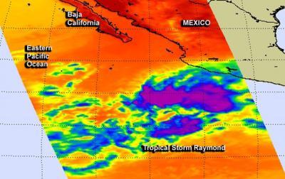
On Oct. 24 at 20:35 UTC/4:35 p.m. EDT, NASA's Aqua satellite passed over Tropical Storm Raymond. The Atmospheric Infrared Sounder or AIRS instrument captured an infrared image of Raymond's cloud top temperatures, showing the coldest, strongest storms that pack the heaviest rainfall had finally moved off-shore. The cloud top temperatures in those strong storms were as cold as -63F/-52C and appeared elongated and somewhat fragmented indicating that Raymond had weakened.
Raymond's rainfall was totaled using data from NASA's Tropical Rainfall Measuring Mission or TRMM satellite, from October 15 to 23, 2013. Rainfall totals were greater than 350mm/ ~13.8 inches along the coast northwest of Acapulco. TRMM data showed that extreme rainfall amounts of over 560mm/~22 inches fell in the open waters of the Pacific where Raymond was stalled.

On Oct. 24 at 4:35 p.m. EDT, NASA's Aqua satellite passed over Tropical Storm Raymond and captured this infrared image of cloud top temperatures, showing the coldest (purple), strongest storms that pack the heaviest rainfall had finally moved off-shore.
(Photo Credit: Image : NASA JPL, Ed Olsen)
Although Raymond weakened on Oct. 24 and early on Oct. 25, forecasters at the National Hurricane Center expect Raymond to move into a more favorable environment over the next couple of days and again reach hurricane status, but over open ocean. By Oct. 31, Halloween, Raymond is expected to move over cooler waters and weaken again.
On Oct. 25 at 0900 UTC/5 a.m. EDT, Tropical Storm Raymond's maximum sustained winds were near 50 mph/85 kph. It was centered near latitude 14.2 north and longitude 108.5 west, about 435 miles/695 km southwest of Manzanillo, Mexico. Raymond was moving to the west at 10 mph, and is expected to continue in that direction over the next couple of days.
Source: NASA/Goddard Space Flight Center