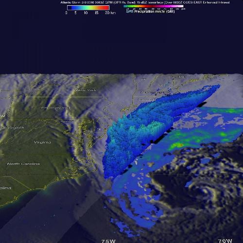
As a low pressure area continued to intensify in the Atlantic Ocean off the United States' East Coast, NASA's Global Precipitation Measurement or GPM core satellite gathered information about the precipitation the storm was packing.
On Feb. 8, 2016, at 3 a.m. EST (0800 UTC) the GPM core observatory satellite flew above an intensifying storm. A rainfall analysis derived from data collected by GPM's Microwave Imager (GMI) and Dual-frequency Precipitation Radar (DPR) instruments with this pass showed a large area of rainfall around the northwestern side of the storm. GPM's radar (DPR) measured rainfall in the Atlantic Ocean east of the Virginia coast falling at a rate of more than 25 mm (almost 1 inch) per hour.
A 3-D cross section that was derived from GPM's Radar (DPR Ku Band) data showed the area of moderate precipitation northwest of the intensifying storm's center of circulation.
 On Feb. 8, 2016, at 3 a.m. EST the GPM core observatory satellite measured rainfall in the Atlantic Ocean east of the Virginia coast falling at a rate of over 25 mm (almost 1 inch) per hour. Credit: Credits: NASA/JAXA/Hal Pierce
GPM is co-managed by both NASA and the Japan Aerospace Exploration Agency.
At 2:50 a.m. EST on Feb. 8, the National Weather Service Weather Prediction Center (NWS NPC) in College Park, Maryland, said, "A strong and impressive low pressure system will move northeastward off the Mid-Atlantic/Northeast U.S. coastline today. The system will spread snow into portions of southern and eastern New England today, with the potential for heavy snow at times as far south as Long Island."
The heaviest snowfall is expected across eastern Massachusetts including Cape Cod, where 8 to 12 inches of snow are possible, with localized amounts exceeding 15 inches. Snowfall amounts of 5 to 10 inches are expected from the eastern half of Long Island northward across southeastern New England.
The low pressure area is also packing strong winds. NWS NPC said the low will generate winds of 30 to 40 mph with gusts as high as 65 mph portions of southeast Massachusetts including Cape Cod and the islands.
source: NASA/Goddard Space Flight Center