Ex-cyclone Haruna is expected to dissipate in the Southern Indian Ocean under increasing wind shear in the next day or two. Infrared imagery from a NASA satellite shows that Haruna is being blown apart several hundred miles away from La Reunion Island.
Wind shear has been a problem for Haruna for days. A night-time image from the VIIRS instrument aboard NASA-NOAA's Suomi NPP satellite taken on Feb. 21 at 22:23 UTC showed the eye of Cyclone Haruna had elongated from northwest to southeast as a result of wind shear. For more information about the Suomi NPP satellite, visit: www.nasa.gov/npp.
On Sunday, Feb. 24, Haruna was centered near 27.2 south and 54.1 east, about 370 nautical miles (425.8 miles/682.5 km) south-southwest of La Reunion Island. Haruna's maximum sustained winds were near 40 knots (46 mph/74 kph) and the storm was moving to the east-southeast at 16 knots (18.4 mph/29.6 kph). An infrared image of Haruna captured by the Moderate Resolution Imaging Spectroradiometer instrument aboard NASA's Terra satellite showed the bulk of the clouds and rainfall were pushed south of the center. The storm was being battered by wind shear and that was pushing the main precipitation away from the center and elongating the storm.
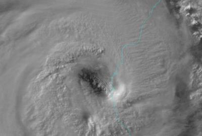
This night-time image from the VIIRS instrument aboard NASA-NOAA's Suomi NPP satellite was captured on Feb. 21 at 22:23 UTC. The image shows the eye of Cyclone Haruna had elongated from northwest to southeast as a result of wind shear.
(Photo Credit: : Univ. of Wisconsin/NASA/NOAA)
On Feb. 24 at 2141 (4:41 p.m. EST), an infrared image from the Atmospheric Infrared Sounder (AIRS) instrument aboard NASA's Aqua satellite showed former Cyclone Haruna blowing apart several hundred miles south of La Reunion Island. AIRS showed that cloud top temperatures had warmed, indicating that cloud heights had dropped and the storm no longer had the strength in uplift that it previously had. For more information about AIRS, visit: http://airs.jpl.nasa.gov/.
The Joint Typhoon Warning Center issued their final advisory on the cyclone on Feb. 24. By Feb. 25 at 0000 UTC (7 p.m. EST/U.S. on Feb. 24) Tropical Cyclone Haruna had maximum sustained winds near 35 knots (40.2 mph/64.8 kph). It was centered near 27.0 south latitude and 57.5 east longitude, about 360 nautical miles south-southwest of La Reunion Island and was moving to the east-northeast at 15 knots (17.2 mph/27.7 kph). Haruna is being battered by wind shear and is expected to dissipate over the next couple of days.
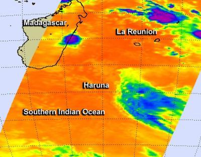
This infrared image from Feb. 24 at 2141 UTC (4:41 p.m. EST) was taken by the AIRS instrument aboard NASA's Aqua satellite. The AIRS image shows former Cyclone Haruna blowing apart several hundred miles south of La Reunion Island.
(Photo Credit: : NASA JPL, Ed Olsen)
Source: NASA/Goddard Space Flight Center