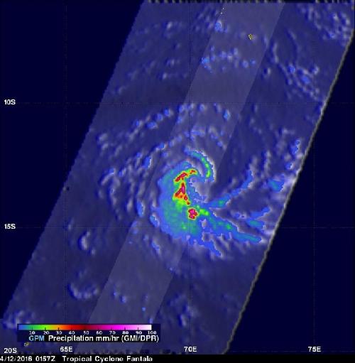
Tropical Cyclone Fantala continued to strengthen in the Southern Indian Ocean and NASA/JAXA's Global Precipitation Measurement (GPM) satellite found very heavy rain in the system.
On April 12, 2016 at 0157 UTC GPM again had a good view of tropical cyclone Fantala when sustained wind speeds had increased to about 45 kts (52 mph). Fantala was getting better organized with GPM showing intense bands spiraling into the center. Precipitation was found by GPM dropping rain at a rate of 189 mm (7.4 inches) per hour in these feeder bands. GPM's radar (DPR) found powerful thunderstorms reaching altitudes of over 16 km (9.9 miles).
At 0900 UTC (5 a.m. EDT) Fantala was located near 19.2 south and 66.7 east, about 488 nautical miles southwest of Diego Garcia. Fantala was moving to the west at 12 knots (13.8 mph/22.2 kph) and had maximum sustained winds near 80 knots (92 mph/148 kph)
 On April 12, 2016 GPM saw Fantala dropping rain at a rate of 189 mm (7.4 inches) per hour in these feeder bands. GPM's radar (DPR) found powerful thunderstorms reaching altitudes of over 16 km (9.9 miles). Credit: Credits: NASA/JAXA/SSAI, Hal Pierce
The Joint Typhoon Warning Center (JTWC) predicts that tropical cyclone Fantala will intensify and have maximum sustained winds of 120 kts (138 mph) in a few days. Fantala is expected to continue heading toward the west and may be a concern for northern Madagascar after April 17, 2016.
source: NASA/Goddard Space Flight Center