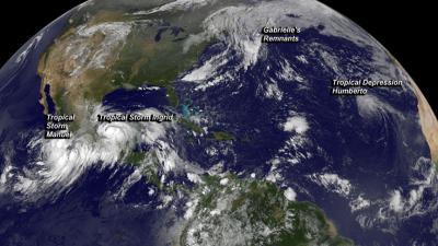
There were three tropical cyclones between the north Eastern Pacific and the North Atlantic Ocean on Saturday, Sept. 14, and NOAA's GOES-East satellite captured them in one image created by NASA. Because Mexico was being hit with Tropical Storm Ingrid and Manuel, both coasts were under Tropical Storm Warnings. The National Hurricane Center cautioned that some areas in eastern and western Mexico may receive up to two feet of rainfall from each storm!
NASA's GOES Project at the NASA Goddard Space Flight Center uses the data gathered by NOAA's GOES series of satellites and makes them into images and animations. On Saturday, Sept. 14 at 1145 UTC/7:45 a.m. EDT, an image was created that showed newborn Tropical Storm Manuel in the eastern Pacific, Tropical Storm Ingrid in the southwestern Gulf of Mexico, the remnants of Gabrielle absorbed into a cold front over the North Atlantic, and Tropical Depression Humberto in the eastern Atlantic.
In the Eastern Pacific, Manuel grew into a tropical storm on Sept. 14. Manuel came from Tropical Depression 13E that developed on Sept. 13, along Mexico's southwestern coast. A tropical storm warning is in effect for Acapulco to Manzanillo.
At 11 a.m. EDT on Saturday, Sept. 14, the center of Tropical Storm Manuel was located near latitude 16.2 north and longitude 102.4 west, about 125 miles/200 km south of Lazaro Cardenas, Mexico. Manuel was moving toward the north near 6 mph/9 kph and was expected to turn north-northwest, meaning that Manuel should be near the coast of southwestern Mexico within the warning area by early Sunday. Maximum sustained winds had increased to near 50 mph/85 kph and a further increase in strength was possible until landfall on Sunday. Manuel was a heavy rainmaker. Manuel was expected to produce 10 to 15 inches of rain over portions of the Mexican states of Oaxaca and Guerrero, with isolated maximum amounts of 25 inches possible. The Mexican weather service received a report of about 8 inches of rain in eastern Oaxaca on Saturday, Sept. 14.

On Saturday, Sept. 14, NOAA's GOES-East saw newborn Tropical Storm Manuel in the eastern Pacific, Tropical Storm Ingrid in the southwestern Gulf of Mexico, the remnants of Gabrielle absorbed into a cold front over the North Atlantic, and Tropical Depression Humberto in the eastern Atlantic.
(Photo Credit: Image : NASA GOES Project)
In the Gulf of Mexico, Ingrid is the big troublemaker. Ingrid continued to ride the extreme southwestern Gulf of Mexico and travel northward along Mexico's east coast. As the center stayed over open waters, Ingrid continued to gain strength and on Saturday morning, Sept. 14 and was nearing hurricane strength. As a result, a hurricane watch is in effect for north of Cabo Rojo to La Pesca, and a Tropical Storm Warning is in effect from Coatzacoalcos to Cabo Rojo. At 11 a.m. EDT on Sept. 14, the center of Tropical Storm Ingrid was located by an Air Force reconnaissance plane near latitude 20.6 north and longitude 94.5 west, about 145 miles/235 km northeast of Veracruz, and 190 miles/305 km east of Tuxpan, Mexico. Maximum sustained winds were near 70 mph/ 110 kph, and Ingrid was forecast to become a hurricane later in the day. Ingrid was moving toward the north near 8 mph/ 13 kph. Ingrid, like Manuel was expected to be a heavy rain maker and was forecast to drop as much as two feet of rain in eastern Mexico. Ingrid was expected to produce 10 to 15 inches of rain over a large part of eastern Mexico with isolated amounts of 25 inches possible.
In the northern Atlantic, Gabrielle's remnants have merged with a cold front, and the system is no more. In GOES imagery, the remnants appear as a large area of clouds stretching from New England to eastern Canada.
In the eastern Atlantic, Humberto became a post-tropical cyclone, although the National Hurricane Center expects it to regenerate in a couple of days. At 11 a.m. EDT on Sept. 14, Humberto's maximum sustained winds were near 40 mph/65 kph. It was centered near 25.4 north and 35.4 west, about 980 miles/1,580 km northwest of the Cape Verde Islands. Maximum sustained winds were near 40 mph/ 65 kph, and Humberto is moving to the west-northwest at 13 mph/20 kph. Humberto is expected to turn to the northwest. Satellite imagery indicates no significant deep convection at this time, however, the National Hurricane Center noted that redevelopment of Humberto into a tropical depression or a tropical storm could occur by Monday, Sept. 16.
Source: NASA/Goddard Space Flight Center