As of July 28, a tropical storm watch is in effect for Texas coast from the mouth of the Rio Grande northward to west of San Luis Pass and those conditions are possible by late Friday.
At 5 a.m. EDT on July 28, Don had maximum sustained winds near 40 mph (65 kmh). It was located about 495 miles (795 east-southeast) of Brownsville, Texas near 23.0 North and 88.7 West. Don's estimated minimum central pressure is 1000 millibars. Don is moving toward the west-northwest near 10 mph (17 kmh) and is expected to continue on this track through Friday, according to the National Hurricane Center. Don is also expected to speed up.
The Brownsville, Texas National Weather Service office posted the tropical storm watch and forecasts "isolated to scattered showers and some thunderstorms and tropical storm force winds will accompany Don as it eventually makes landfall in south or deep South Texas."
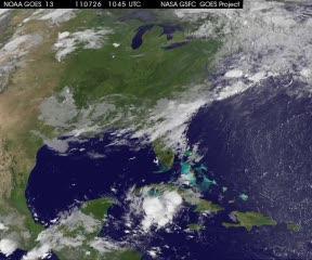
GOES-13 data was compiled into an animation by the NASA GOES Project at NASA Goddard that shows the development of Tropical Storm Don in the southern Gulf of Mexico, west of Cuba. The animation runs from July 26 at 1315 UTC (9:15 a.m. EDT) to July 28 at 1045 UTC (6:45 a.m. EDT).
(Photo Credit: NASA/NOAA GOES Project)
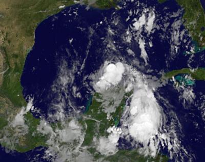
This infrared image of Tropical Storm Don from the GOES-13 satellite at 1101 UTC (7:01 a.m. EDT) on July 28 shows a small storm that appears somewhat disorganized, near the Yucatan Peninsula of Mexico.
(Photo Credit: NASA/NOAA GOES Project)
Source: NASA/Goddard Space Flight Center