Tropical Depression 2 formed at 5 p.m. EDT on Sunday, July 17. At that time it had maximum sustained winds near 35 mph and was just 100 miles northwest of Great Abaco Island, near 27.5 N and 78.2 W. The Abaco Islands are located in the northern Bahamas and are made up of the main islands of Great Abaco and Little Abaco with many smaller islands called "cays."
On July 18 at 8 a.m. EDT, Tropical Depression 2 strengthened into Tropical Storm Bret. Maximum sustained winds were up to 50 mph. At that time, Bret was just 65 miles north-northwest of Great Abaco Island (and about 200 miles off the eastern Florida coast) near 27.4N 77.5W, trudging along at 3 mph to the northeast. Minimum central pressure is 1001 millibars.
The National Hurricane Center has issued a tropical storm warning for Grand Bahama Island and the Abaco Islands in the northwest Bahamas. As a result, the northwestern Bahamas are 'under the gun' for the greatest impacts from Bret. Rainfall could reach between 2 and 4 inches, while winds can reach tropical storm-force today. Those winds should diminish tonight as Bret pulls away. Beach goers will have stay away from the ocean as locally high surf conditions are expected along northern and western facing beaches today.
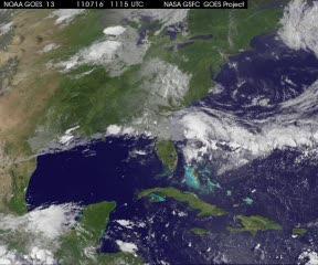
GOES-13 satellite imagery in 15 minute intervals from July 16 at 7:31 a.m. EDT until July 18 at 7:31 a.m. EDT shows Bret developing from a low pressure area in the northwestern Bahamas.
(Photo Credit: NASA/NOAA GOES Project, Dennis Chesters)
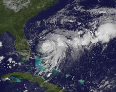
This visible image of Bret was taken from the GOES-13 satellite on July 18 at 11:31 UTC (7:31 a.m. EDT) and shows the storm over the northwestern Bahamas.
(Photo Credit: NASA/NOAA GOES Project, Dennis Chesters)
Source: NASA/Goddard Space Flight Center