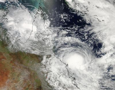
On Friday, March 7 there were two tropical lows located east and west of Queensland, Australia. Those lows organized and intensified into Tropical Cyclone Gillian and Hadi and were caught together in one amazing image from NASA's Aqua satellite. While Gillian has already made one landfall and is expected to make another, Hadi is turning tail and running from the mainland.
NASA's Aqua satellite passed over Queensland on March 10 at 04:00 UTC and the Moderate Resolution Imaging Spectroradiometer instrument known as MODIS captured Tropical Cyclones Gillian in the Gulf of Carpentaria, just west of Queensland's York Peninsula, and Hadi in the Coral Sea, east of Queensland.
On March 10 at 0300 UTC, Tropical Cyclone Gillian, formerly known as the low pressure area "System 98P" had maximum sustained winds near 35 knots/40 mph/62 kph. It was located about 230 nautical miles northeast of Mornington Island. Gillian is moving to the southeast at 5 knots/5.7 mph/9.2 kph, but is expected to re-curve to the southwest.
The Joint Typhoon Warning Center or JTWC noted that animated multi-spectral satellite imagery and radar from Weipa showed that the center made landfall in the northwestern coast of the York Peninsula. Gillian's center is also being battered by moderate northeasterly vertical wind shear, which is preventing any further intensification, but that's expected to change as Gillian turns back toward the Gulf. The JTWC expects Gillian to re-emerge in the Gulf of Carpentaria and head in a southwesterly direction, passing west of Mornington Island (located in the southern Gulf). JTWC forecasts Gillian to make its second and final landfall on the mainland near the Northern Territory/Queensland border on March 13.

NASA's Aqua satellite passed over Queensland on March 10 at 04:00 UTC and captured Tropical Cyclones Gillian (left) in the Gulf of Carpentaria, just west of Queensland's York Peninsula, and Hadi (right) in the Coral Sea, east of Queensland.
(Photo Credit: NASA Goddard MODIS Rapid Response Team)
The Australian Bureau of Meteorology noted on March 10, that residents from Burketown to the Queensland / Northern Territory border, including Mornington Island and Sweers Island should consider what action they will need to take if the cyclone threat increases.
Tropical Cyclone Hadi, formerly tropical low pressure area "System 96P" lingered off the coast of eastern Queensland near Willis Island on March 8 and 9 and is now being pushed northeast and out to sea.
On March 10 at 0900 UTC/5 a.m. EDT, Tropical Cyclone Hadi had maximum sustained winds near 35 knots/40 mph/62 kph. It was located about 176 nautical miles east-southeast of Willis Island, near 18.8 south and 151.3 east. Hadi was moving slowly to the east-southeast at 4 knots/4.6 mph/7.4 kph.
Satellite imagery showed moderate to strong vertical wind shear, between 20 and 30 knots/23.0 and 34.5 mph / 37.0 and 55.5 kph pushed the strongest thunderstorms south of the center of circulation. The JTWC expects Hadi to strengthen to 55 knots/63.2 mph/101.9 kph as it tracks to the northeast over the next several days.
Source: NASA/Goddard Space Flight Center